Showing posts with label Indus. Show all posts

Sunday, April 28, 2024

Invaders of the land of seven Rivers - Chapter 1


1. The land of Saptasindhavah (सप्तसिन्धवः)


Since the dawn of civilization, the mighty Himalayas have always protected the people living in Indian sub-continent, not only from natural phenomena like sandstorms originating on central Asia plains or blistering arctic cold winds or great floodwaters sweeping the north Indian plains,  that could have created existential problems for the early settlers. The unscalable peaks and ranges of world’s tallest mountain also prevented the barbaric wild Asian steppe hordes, attacking and destroying the inhabitations, including cities and towns of subcontinent, the way they did in China and east Europe.

Yet, in spite of this guardian angel, protecting our borders, wild hordes of invaders and intruders, cruel and murderous tribesmen, monarchs, brave warriors with monarchy aspirations and people who themselves were pushed out from their country, found routes that circumambulated  the vast mountain ranges and enter the sub-continent over last two millennia. These intruders and their barbaric armies, created a profound impact on the culture of the sub-continent that had evolved over last five or more millennia, starting from Sindhu-Sarswati Civilization, the Vedic era, Buddhist ideas and finally the Sanatan Dharma. Some of the early intruders adopted to native religions, but some imposed their own religious doctrines, creating a great divisive force that continues to torment the sub-continent, even today.  

It so happens that the most profound impact of the intruders took place in a geographical area of the subcontinent, where Sindhu-Sarswati civilization once flourished five or more millennia ago. This land could be rightly called as the heart or core of the sub-continent culture. This region, in the northwest corner of the sub-continent, is none other than the land of seven rivers or Saptasindhavah (सप्तसिन्धवः) of the Vedas.  

In the oldest Veda or Rigveda, the sage Angirasa, while offering oblation to Sun God ‘Savita” describes him as,
अ॒ष्टौ व्य॑ख्यत्क॒कुभः॑ पृथि॒व्यास्त्री धन्व॒ योज॑ना स॒प्त सिन्धू॑न् । हि॒र॒ण्या॒क्षः स॑वि॒ता दे॒व आगा॒द्दध॒द्रत्ना॑ दा॒शुषे॒ वार्या॑णि ॥ (1.35.8)
“He has lighted up the eight points of the horizon, the three regions of living beings, the seven rivers; may the golden-eyes Savitā come hither, bestowing upon the offerer of the oblation desirable riches.”

The next question that naturally arises is the names of rivers that constitute this land of seven rivers.  Luckily Rigveda helps us even here. The Nadistuti sukta (नदिस्तुति सूक्त), or "the hymn in praise of rivers", gives us names of these seven rivers for the reconstruction of the geography of this area.

The first and foremost river that this Sukta (10.75.1) mentions is obviously Sindhu or The Indus, the mightiest of them all. Other rivers that are mentioned (10.75.5) in east to west direction are Sarasvati, Shutudri (Sutlej), Parushni (Iravati, Ravi), Asikni (Chenab) and finally Vitasta (Jhelum). This defines the land of seven rivers as the region that begins with Sarswati in the east, but does not end with Indus in the west.  

The next verse (10.75.6) describes the tributaries like Kubha (Kabul River), Gomati (Gomal) and  Krumu (Kurram),that merge with Sindhu in the plains.  Using this information, we can create a map of the landmass, which Rigveda describes as ‘Saptasindhav’. We must also include here the plains, west of Indus River that stretch to the mountains and also the Basin of no longer visible  Sarswati River, now found only through archaeological and satellite data. However, we shall not indulge in that endeavor as it is unrelated to our subject matter.   Figure 1.1 shows the exact locations of these rivers except River Sarswati.

 By Dbachmann, CC BY-SA 3.0, https://commons.wikimedia.org/w/index.php?curid=883227


From the image, we can imagine the vastness of this landmass. Considering present political situation, it consists of entire country of Pakistan, some parts of Afghanistan and Indian Punjab. Before we proceed further, it is important to clarify an issue, in which a few people, particularly from our western neighbor tend to believe.  After discovery of Indus culture (Now called Sindhu-Sarswati civilization) by Mr. Banerji of Archaeological survey of India, European historians started endorsing an imaginary idea of Aryan invasion, on land of seven Rivers and destruction of so called native or ‘Anarya’ culture that existed there before. However, the archeological and other data from extensive excavations in Saraswati basin by Archaeological Survey of India, Deccan College Pune and others have conclusively proved that no evidence have been found anywhere that can support this theory and the Aryan invasion theory stands rejected.

We can say with confidence therefore that history of land of seven Rivers, during Sindhu- Sarswati civilization does not include any major military campaigns by outsiders and it got extinguished due to several other reasons, which are out of our scope. Next we come to Vedic period (1500-to-1200 BCE) and Mahabharata (840 BCE) period, where major wars were only fought by indigenous armies and no external army or power was involved.  This however does not mean there were no wars fought between ‘Saptasindhav’ kingdoms and ‘Tochari’ people, their northwest neighbours. These probably were just local conflicts as no large scale invasion record has been found anywhere.

From Mahabharata period we shall move ahead by two three centuries or so and we come to a period around middle of sixth century BCE. Buddhism was spreading fast in north and northwest India.  With the monks travelling everywhere in the region, information about India, its riches, was spreading very fast.  It was no wonder therefore that foreign powers, kings and monarchs, ever eager to expand their kingdoms and monarchies, must have gathered this information and plans were afoot to invade this golden land.

With this background, we can label the arrival of the first invader army to land of seven Rivers as beginning of an evil period that intermittently continued until 1760 CE, only to be replaced by an even more cunning adversary, the British and later bifurcation of this most fertile and beautiful land itself.

(To be continued)


27th April 2024


Thursday, August 14, 2014

Can Saraswati river be revived?


If there ever was a single entity that could be called as an epitome or paradigm of the ancient Vedic culture civilization of pre-historic India, it was surely the mythical river Saraswati. It is now believed that the entire Vedic culture did blossom and bloom along the banks of this mythical and grandest of all rivers in India. Since the river was never seen in the known historical period of India, a legend grew which said that the river was invisible. Lay people did believe in this legend but for more scientifically minded souls, some kind of proof was necessary to accept it's existence.

The story of the discovery of this once mighty but later thought to be invisible river is quite fascinating. To begin, let us first move to the vast marshy land known as Rann, sandwiched between India's Kutch region and Pakistan's Sind province. Up to 1918, a river known as Kori river flowed from Sind into the Rann, eventually emptying itself in Arabian sea through what is known as Kori creek. From the times of Alexander the great (325 BC) and Ptolemy (150 AD) this Kori river was always thought to be a subsidiary of the mighty Indus and Kori creek was called as eastern mouth of the Indus. In 1819, a major earth quake struck the region. As a result of earthquake, entire Sindh shoreline north of Rann rose up like a bund known as “Allah's Bund” or God's Bund. This God's bund effectively closed the eastern mouth of the Indus or Kori river forever. The lost Kori river is of special relevance to our story as would be clear later. In 1870, a geologist Alex Rogers discovered Alluvium or sand, mud, deposits formed by flowing water in Gulf of Khambat, suggesting a past presence of a major river system in the area. In 1886, a British officer, Oldham, reported finding a vast dry bed of a river, through which a much smaller seasonal monsoon fed river, known as Ghaggar now flowed. Ghaggar river, originates near Ropar in Punjab and dissipates itself in the sands of Rajasthan deserts.


In 1921, finding of Mohenjodaro city, on the bank of Indus river, led to the discovery of the most ancient civilization of Indian sub continent, known as the Indus civilization, that existed during 5000 to 2500 BCE. European historians came up with many fancy theories after this discovery, about Aryan invasion of India that was supposed to have destroyed the newly found Indus civilization and that is what was generally believed till even three or four decades ago.

Extensive excavations carried out by the Archaeological survey of India along the banks of the dry bed of Ghaggar river, has brought to light, hundreds of places, like Kalibangan, Rakhigarhi and Ganweriwala, where chalcolithic civilizations thrived once, during 3500 to 2500 BCE. Discovery of the port city of Dholavira further supported the historical fact that the now marshland of Rann, was once a navigable channel of water, mainly fed by Sarswati waters.


Mr. R.N. Athavale, is a former Scientist with National Geophysical Research Institute, Hyderabad, and Emeritus Scientist, CSIR, India. He was involved in the research work concerning Saraswati basin. He says that by 2008, most of the scientists believed that the ancient Saraswati river was not mythical but originated in Himachal Pradesh, entered Haryana near Kalka, moved through Punjab and Haryana into Rajasthan, meandered and wound further downstream, till it debouched in the Gulf of Katch. The river is currently known as Ghaggar River in its upper reaches and Hakra and Nara in the lower reaches. The Ghaggar today is an ephemeral stream fed only by monsoon waters. In the past, several major and minor tributaries joined the Sarasvati over its course. The relevance of Kori river would now be clear. Kori probably was not the mouth of Indus but Saraswati. (Sankaran, A.V., 1999; Roy and Jakhar, 2001)

Another report on a study, was published on 28th May 2012 in the Proceedings of the National Academy of Sciences and lead authored by Liviu Giosan, a geologist with Woods Hole Oceanographic Institution (WHOI), that claimed to have found the answer to the Saraswati riddle. The study was done from 2003 to 2008 from the Arabian Sea coast to the fertile valleys of Punjab and the northern Thar Desert in Pakistan. Over this period, Liviu Giosan's team of 15 international experts, which Included Prof Ronojoy Adhikari of the Institute of Mathematical Sciences, Chennai, studied satellite photos and topographic data collected by the Shuttle Radar Topography Mission. From this data the team created digital maps of landforms in the basins of Indus and other rivers. This analytical work was then confirmed with help of field work in the area, consisting of drilling, taking core samples and digging deep trenches to study cross-sectional views. The report says that archeological evidence suggests very intensive human settlements during Harappan times in the basin of Ghaggar-Hakra river, which is believed to be the long lost Sarswati of the Vedas. The geological evidence like presence of sediments, topography discovered in this study shows that these rivers (Ghaggar-Hakra)were indeed sizable and highly active in this region, most likely due to strong monsoons, during Harappan period.


We now come to the next question. How did the Saraswati river disappear. Everyone agrees that it disappeared sometime between 5000 and 3000 BCE. However there are tow schools of thought for the reasons behind this disappearance. Liviu Giosan report assigns gradually weakening monsoon rains as the main reason for drying up of Sarswati, whereas CSIR scientists believe that The Sarasvati river system was always a separate entity and was never part of the Indus basin. It dried up a few thousand years back, due to tectonic movements, tributary diversions and climate changes, when it was no longer fed by the Himalayan snow.

Whatever may be the reasons, the fact remains that the dry courses of the main river and its tributaries are at present covered with sand, loam and silt, deposited by wind over last few thousand years and they could be discerned only after the advent of satellite remote sensing techniques.

Readers might have felt puzzled for my bringing up this subject now, but there is reason for that. India's federal minister for water resources and river development minister has just announced that Government plans to take up the issue very seriously to trace the route of the river.

I do not know, what purpose would be served by taking up this study as everyone in the scientific community knows that the Saraswati river is not a myth. Satellite images of northwestern India shows presence of underground channels of water below the river bed and the water has been found to be at least 3500 years old by scientists. It is also known that the river passed through plains of Punjab, Haryana, Rajasthan, Gujarat and finally emptied in the Arabian sea through the great Rann.

Some people want the river to be revived. It could be a game changer as river once flowed through zones that are arid and desert like today. It can certainly bring riches and wealth to the arid region no doubt. To do this, we may have to divert the waters of Satlaj and Yamuna rivers in the bed of Ghaggar. Though technically it is feasible, there are other difficulties that are of political nature. Satlaj ultimately meets Indus river, which now is in Pakistan. Satlaj water is shared by the two countries as per an international agreement. Pakistan is unlikely to allow diversion of Satlaj water to India. This means that we can only divert some of the Yamuna water to Ghaggar, which in any case may not bring back the former glory to Sarswati.

Another major difficulty is that the dry bed of Saraswati in the lower reaches almost entirely falls within political boundaries of Pakistan. A question naturally arises as to why should we divert eastwards flowing Yamuna waters to Sarswati bed, if ultimately it will go to Pakistan. The idea of revival therefore is a non starter and would work to some extent if Pakistan agrees to diversion of Satlaj waters because finally it would be going back to that country only. Without Pakistan's cooperation, any talk of revival of Saraswati has no meaning at all.

There is another possibility though, as suggested by Mr. R.N. Athavale. The states of Punjab and Haryana and to some extent similarly affected irrigated parts of Rajasthan, are today facing the problem of disposal of the water drained out from the thousands of hectares of waterlogged, salinized and erstwhile fertile areas. The problem is considered as the most difficult aspect of reclamation through man made sub surface drainage. It is suggested that the presently dry and pristine sub surface beds of the Sarasvati and its tributaries in the desert area, can be used to dispose off the water collected through a network of sub surface drains. This appears to me as the most practical solution as excess waters would be carried to the arid region because of the natural slope of the river course. Since this water flow is not likely to be very large, it need not flow to Pakistan at all and could be used for agriculture in Rajasthan alone.

I feel that any other plan for revival of Sarswati would prove to be a non starter.

14th August 2014


Tuesday, January 15, 2013

The Surkotada horse, Part III


(continued from )

With the theory of Aryan invasion to the Indian sub continent in the pre-historic times no longer being acceptable, the reasons for demise of the Indus-Ghaggar civilizations after flourishing over several millennia remained a great puzzle for the historians and the archaeologists till now. A report of a study, published on 28th May 2012 in the Proceedings of the National Academy of Sciences and lead authored by Liviu Giosan, a geologist with Woods Hole Oceanographic Institution (WHOI) claims that they have found the answer to this riddle. I have described in details, the findings of this research team in an earlier article, which anyone interested can go through. However, for sense of continuity, I am repeating here, some of the main observations from this report.
Before massive human habitation of Indus-Ghaggar civilizations had settled in, for previous ten thousand years, wildly flowing river Indus and its tributaries had deposited rich soil sediments on stretches between them. The research team led by Giosan has been able to discover a massive mega-ridge 10 to 20 meters high, over 100 kilometers wide, and running almost 1000 kilometers along the Indus, in this mounded plains. It has been named as "Indus mega-ridge," as it was constructed by the river itself with sediments deposited along it's entire lower course. Remains of Harappan settlements, which are found today are not buried underground in this ridge but rather lie at the surface of the ridge.

The monsoon rains that brought floods to the rivers, actually started declining with time. Weakened monsoon rains and reduced run-off from the mountains, helped in taming the wild Indus and its Himalayan tributaries, so that agriculture along their banks became possible. As a result, human settlements bloomed along the Indus and its tributaries from the coast to the foothills of the Himalayas. The weakened monsoon rains created a window of about 2000 years in which Harappans took advantage of the opportunity and a great civilization arose on the banks of Indus and tributaries. Indus civilization, was built on bumper crop surpluses along the Indus and the Ghaggar-Hakra rivers from this earlier wetter era and required a huge concentration of workforce. This workforce requirement developed into great urban centers like Mohenjodaro and Harrapa.


As monsoon weakened progressively, this window of prosperity began closing and widespread aridification of the lands, where plenty of water was available earlier, drove the Harappans eastwards east or towards Ganga river by 1500 BCE, where monsoon rains remained reliable. The economic structure in the east with local rain-fed farming and dwindling streams could only support smaller agricultural surpluses and could not support large cities of Indus civilization. The cities collapsed and with them the urban arts such as writing. The population in Ganga basin now dispersed in small agricultural communities, survived and even diversified.

The study also reports another major finding, which solves the riddle of Sarswati river. Archeological evidence suggests very intensive human settlements during Harappan times in the basin of Ghaggar-Hakra river, which is believed to be the long lost Sarswati of the Vedas. The geological evidence like presence of sediments, topography discovered in this study shows that these rivers were indeed sizable and highly active in this region, most likely due to strong monsoons, during Harappan period. However these rivers were not Himalaya fed rivers. There is no evidence of waters of nearby Himalayn rivers like Satlaj or Yamuna flowing in this river. The study therefore suggests that Sarswati or Ghaggar-Hakra river was a monsoon fed perennial watercourse and the aridification reduced it to short seasonal flows like at present. but most likely due to strong monsoons. 

However some Indian scientists do not agree with this analysis. They feel that the Sarasvati river system can be considered as a separate entity and not as a part of the Indus basin. It dried up a few thousand years back, due to tectonic movements, tributary diversions and climate changes. This thesis is now well documented and accepted by almost all, barring a few skeptics. The dry courses of the main river and its tributaries are at present covered with sand, loam and silt, deposited by wind over last few thousand years. They could be discerned only after the advent of remote sensing techniques. (Sankaran, A.V., 1999; Roy and Jakhar, 2001).

I would only like to add that whatever may be the actual reason, end result happens to be the same.   

In addition to shifting of monsoons, Harappan cities in the south like Dholavira faced another natural calamity. The archaeologists excavating Dholavira have already found out the damages caused by a massive earth quake. Similar earthquakes must have changed the entire geographical structure here and a region once extremely fertile became an arid and marshy zone. As Giosan suggests, the populations of the Indus civilizations of the south must have simply dispersed to further south (Gujarat) and the east (Rajasthan), where better weather conditions must have prevailed.

Some of the archaeologists suggest that the Saraswati or Ghaggar river, once emptied itself into Arabian sea just, north of Rann of Kutch, what is called as Kori creek today. If this was the case indeed, one can imagine, how fertile and prosperous the region around Dholavira and Surkotada must have been.


Two years before, I paid a visit to the National Museum in New Delhi. This museum has a great collection of many items and artifacts from Indus civilizations. I found that a number of things like bullock cart designs, kitchen utensils, toys were very similar to what was in use even about 50 years before, in India. To me, Indus civilization legacy to Indians is not lost but continues even today.


The then director general of the Archarological survey of India, Mr. Braj Basi Lal had addressed a gathering in the Indian city of Bhopal, arranged by National Council for Education, Research and Training (NCERT) in November 2002. In his speech, Mr.Lal had highlighted the similarities between Harappa culture and The present Indian culture. I quote: 

" whichever walk of life you talk about, you will find in it the reflection of the Harappa Culture: be it agriculture, cooking habits, personal make-up, ornaments, objects of toiletry, games played by children or adults, transport by road or river, folk tales, religious practices and so on. Here we give just a few examples. The excavation at Kalibangan has brought to light an agricultural field dating back to circa 2800 BC. It is characterised by a criss-cross pattern of the furrows. Exactly the same pattern of ploughing the fields is followed even today in northern Rajasthan, Haryana and western Uttar Pradesh. Today mustard is grown in the widely-distanced furrows and chickpea in the narrower ones and it is most likely that these very crops were grown in a similar manner during the Harappan times; we do have evidence of both these items from the Harappan levels. Kalibangan has also yielded a linga-cum-yoni of the same type as is worshipped now. This very site, along with Banawali, Rakhigarhi and Lothal, has brought to light 'fire-altars', indicating rituals associated with fire. ”
Some other parts of Mr. Lal predicts a totally different course of history, but is is better to leave it to the experts. What I find important here is the thought that Indus-Sarswati civilizations never really were wiped out but rather continued in other parts of India with blooming of the Vedic culture.


I have mentioned above that the inhabitants of the southern habitats of Indus civilization migrated towards Rajasthan, Gujarat and Maharashtra. It is natural to question existence of any evidence to support this claim. Luckily extensive excavations carried out by archaeologists from Deccan College, Pune in the basin of Pravara river (a tributary of the giant Godavari river) have brought up such conclusive evidence. The Archaeologists call the Chalcolithic culture of the people of peninsular India in the time period between 1700 to 1400 BCE as 'Malwa Culture.' Great similarities are observed between this culture and Mature Harappan culture from places like Dholavira and Surkotada. In a place called as Daimabad a local farmer, Chhabu Laxman Bhil , found a hoard of four bronze objects  in 1974. One of the objects is a sculpture of a chariot, 45 cm long and 16 cm wide, yoked to two oxen, driven by a man 16 cm high standing in it. This chariot along with other sculptures of animals are so exquisite that they have completely baffled the Archaeologists.

 Oxen pulled  Bronze chariot found at Daimabad in Maharshtra


Figurines of mother Goddess with a bull, found at Inamgaon
 
Inamgaon is a small village south of the Pravara basin, on the banks of River 'Ghod.' The excavations carried out here have revealed human settlements here that lasted for an extended period starting from 1700 BCE to 800 BCE. In this period, three independent cultures with their own differentiable and exquisite features were found to exist here. These are known to Archaeologists as Malwa, early Jorwe and late Jorwe cultures. Inamgaon habitat more or less proves the spread of Sindhu civilzation to east and south, where it got mixed and assimilated with other Indian neolithic cultures from India. Another important finding of Inamgaon excavation is continuing worship of mother goddess or Goddess of fertility from the Indus civilization. 

 
Now we come to the last point regarding adoption of Vedic religion by India somewhere in second millennium BC. There are serious differences of opinion between historians about exact plave of origin of the Vedic culture. Historian Romila Thapar along with others believe that Vedic religion originated in Marginia/Bactria region of northern Afghanistan, whereas Mr. B.B. Lal, whom I have mentioned above believes that Vedic culture originated on the banks of Sarswati river. Whatever may be the place of origin, the real point of interest is how this new religion managed to uproot the Lingam and fertility idol worship of the Harrapans with a vedic religion, which had no idols. I want to compare this to more modern adoption of Buddhism by many countries in Asia such as China, Japan, Korea and Thailand. Around 300 BCE, Indian emperor Ashoka sent Buddhist monks all over Asia to spread this new religion. There was no question of forcing anyone or no coercion. Yet we find that these countries adopted Buddhism. I feel that Indians must have adopted Vedic culture in this fashion, still keeping some elements of Indus religions and cultures in the new religion. The best examples of this could be the retaining of Durga or the mother goddess and Lingam, now associated with Rudra (an original Vedic God) in the new culture.

A recent genetic study by India's Council of Scientific research suggests that modern humans have migrated to India from three origins: the central Asia, Malaysia and Andaman islands. It is quite likely that the Indus civilization people came there from central Asia, settled down there for 2 or 3 millenniums and later, when things became tough, again moved eastwards and southwards. Indus civilization never really saw it's demise. It just moved eastwards and southwards.

(Concluded)

15 January 2013


Friday, January 20, 2012

Ladakh Escapades Part III


Friday

I wake up rather early. The night has been unexpectedly cold here in Lamayuru. The month of July is considered the hottest month in Ladakh. Even then, the night was appreciably chilly. It must be getting really freezing here in later months, I wonder. Fortunately there is electrical power available at this time. I put on the electric water boiler and enjoy the luxury of a really hot water bath. After a rather sumptuous breakfast, I am ready for the return journey to Leh. I find that our driver and the car missing again. I get absolutely peeved now with this character. I telephone my travel agent in Leh and request him to help me. Within 15 minutes, the driver makes an appearance. Obviously, he has just woken up from his sleep. I would have to wait till he is ready. After ages, we are ready to leave. I try to discuss with the driver, plan for today. He is not very co-operative. Finally another person, who is a representative of my travel agent, appears on the scene. He has a lengthy discussion with the driver and finally the matter is settled. We would visit four places of interest on our way back to Leh. By now I am so irritated with this driver, that I decide to dump him later. I would have to take on, another driver from tomorrow. 

Sunday, November 13, 2011

The Strongest takes all.

During early part of last year, news items started appearing in Indian media that China has started building a huge dam somewhere in Tibet on the Yarlungzangbo ( Yarlong Tsangpo as known to Tibetans)or Brahmaputra river. This project, known as ‘Zangmu hydroelectrical project’ was supposed to have been inaugurated on March 16,2009 and the first concrete was poured on April 2, 2009. The 1.138-billion Yuan (1 Yuan = $0.15) project was awarded to a five-company consortium with China Gezhouba Group along with NIDR (China Water Northeastern investigation, design and research) involved in its construction. This dam was expected to generate 540 MW of electrical power. As per design plans, the Zangmu dam was supposed to be a gravity dam with water-blocking structures, which could mean construction of a reservoir.


The Zangmu dam was reported to be a part of a Chinese plan to have a series of five medium-sized dams along the river in the Nanshan region of Tibet at Zangmu, Jiacha or Gyatsa, Zhongda, Jiexu and Langzhen. As expected, there was a tremendous hue and cry over this supposed Chinese river plan in India and two Indian State Govenments even requested the Central Government to take up the matter with Chinese Government and see that the project is stopped immediately.
This matter having come up at the time of the visit of Chinese President Hu Jintao to India, Chinese authorities were quick in rejecting the news as a baseless rumour to quell Indian public fears and sentiments. China’s Minister for Water Resources, Wang Shucheng, said the proposal was “unnecessary, unfeasible and unscientific, and had no government backing.” The China Daily reported, Wang Shucheng even saying that “There is no need for such dramatic and unscientific projects”. Later, Chinese Foreign Ministry spokesman Liu Jianchao said (according to the China Daily) that “The Chinese government has no plans to build a dam on the Yarlung Zangbo River”. The whole controversy seemed to have originated from a proposal, promoted by a group of retired Chinese officials earlier last year, to divert the waters of, what becomes the Brahmaputra River to China. These officials had floated these ideas in their book entitled ‘ Tibet’s water will save China’ published last year and had received a burst of publicity in China.
However, from various reports that now appear on internet, it looks almost certain that in spite of the denials, the Zangmu Hydroelectric Project, is indeed in construction. and the project is expected to be completed by 2013. This project is however just a run of the river, hydro-electrical generation project, taking advantage of the steep fall the Yarlung zangbo river has in this region and without any water diversion from the river. This should not concern India at all as the Brahmaputra river would continue to bring in same amount of water to India in future also. In fact, even if the Chinese build all the five dams on the river as planned, it would be of little consequence to India provided these are run of the river projects and there is no water diversion.
If what Chinese are saying about not diverting Yarlungzangbo river water is true, it only means that at this point of time, they must have found it to be a political hot potato and must have weighed the consequences of such an action, which directly goes against Indian and Bangladeshi Interests and must have decided to hold off any such plans for future. India (and Bangladesh) therefore, have nothing to worry about Brahmaputra waters at least for the present. Other countries, which share common borders with China, may not be that lucky.


Six of World’s mightiest rivers, Yellow, Yangtze, Brahmaputra, Indus, Salween and Mekong, all rise from the Tibetan Plateau and flow in Easterly or Northerly directions . Except for Yellow and Yangtze rivers, which flow in the Chinese mainland, all of the four remaining rivers, eventually cross Chinese borders and flow into Myanmar, Thailand, Laos, India ( not in that order) and also into illegally occupied part of Kashmir in possession of Pakistan.
A Canadian documentary maker, Michael Buckley, during his several trips to Tibet, accidentally discovered that Tibet’s river systems are being strangled by large scale dam construction. He along with a group of backpackers, moving through Tibet , discovered many newly constructed dams in the region built to divert water and hydro energy to China. China’s own river system, has been so devastated by uncontrolled industrialization that it has resulted in 70 percent of the nation’s water supply being undrinkable and unable to support aquatic life. In fact,the Dri Chu, or Yak River, which becomes the Yangtze—one of China’s most famous rivers, along with the Yellow River, now fail to reach the sea.
He says that “The rivers are dead. Chinese are not trying to fix their rivers. Their solutions are ‘Let’s take the water from Tibet’”. He feels that the diversion of water from the Tibetan highlands, to parts of northern China, is in planning stages and will be done via a vast network of concrete conduits. He says further that “China’s grand pipe-dream is to divert abundant water from the Tibetan highlands to reach water-starved cities of the north and west of China, which have around 300 million people. A diversion project of this scale enters a realm beyond anything ever attempted in water engineering.”
“The electricity produced via the hydro dams in Tibet, he added, is not for Tibetans but for Chinese industry downstream.” Michael Buckley has even produced a documentary entitled ‘Meltdown in Tibet’ on the subject.
All the downstream and riparian economy countries, except perhaps Pakistan, have realized and suddenly became aware of the threat to their water systems, as China continues to build huge dams on these rivers in Tibet and Yunnan. In fact their entire river economies are suddenly in danger.


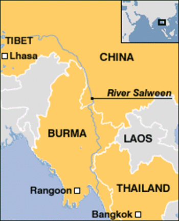
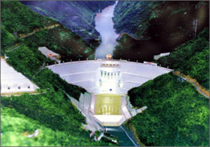
Salween river rises at 1,578 metres (5,177 ft) in the Qinghai Mountains on the Tibetan Plateau, near the headwaters of the Mekong and Yangtze rivers. It flows through China, Burma, and Thailand and empties into the Andaman Sea. The river is known as Gyalmo Ngulchu in Tibetan, meaning ‘ The Queen of Silver Water’. Canadian documentary maker Michael Buckley says that “Despite widespread protest from within China and from neighboring countries in Asia, Chinese engineers are forging ahead with plans for a cascade of 13 large dams on the Salween. Several dams are already under construction,one the height of a 60-story building.”


River Indus or Sindhu as we call it, rises in the Tibetan plateau in the vicinity of Lake Mansarovar in Tibet Autonomous Region of China. The river runs a course through the Ladakh district of Jammu and Kashmir and then enters Northern Areas (Gilgit-Baltistan) in possesion of Pakistan. Flowing in a southerly direction along the entire length of the country of Pakistan, it merges into the Arabian Sea near port city of Karachi in Sindh.
Alice Albinia, a British journalist and writer who recently visited Indus up to its roots, says in her book ‘ Empires of the Indus ‘ that the greater part of water in the River Indus came from its upper reaches, from Tibet, Ladakh and Baltistan, rather than from its Himalayan tributaries in the Punjab. She recently visited the Indus from its end point Indus Delta to its catchment area and the point of start called Senge Khabad by Tibetans, which means the lion’s mouth. It is the only place, where water did not flow from the glaciers, but the ground, and flow continued round the year.


On her way to Senge Khabab, she saw a huge dam with massive concrete curve looms up from the riverbed. The structure itself was complete, but the hydroelectric elements on the riverbed were still being installed. There are pools of water this side of the dam, but no flow. The Indus has been stopped. China had not officially informed the government of Pakistan, as there is no treaty between China and Pakistan over shared waters.
Recent Satellite Photo shows huge amount of Indus water grabbed by China, which otherwise would have flown to Pakistan
Moreover when this book was released in Pakistan, the water experts there, first refused to accept the building of a large dam in Tibet by China. Later they have simply rejected the idea of Indus water getting depleted by such a dam. This Senge Khabab dam is situated at 32 degrees and 31 minutes North latitude, and 80 degrees and 10 minutes East longitude. It is built on a tributary of Indus River, which flows from East to West joining the main (Indus) river at 32 degrees and 31 minutes North latitude, and 79 degrees and 42 minutes East longitude near the Ngari township and can be easily seen on Google Earth. The Hydroelectric power station named as Sengye Tsangpo Hydropower Station has an installed capacity of 6,400 Kilowatts and is now operational.


Now we come to perhaps the biggest and greatest grab of an international river water done by Chinese. The Dza Chu, or Mekong River, begins its life again in the mountains of Tibet and becomes a roaring torrent as it swirls through deep gorges, dropping an astonishing 4,500 meters [14,800 feet] in elevation through Tibet and China, over a distance of 1,800 km [1,118 miles],before turning tamer to enter Laos.the river is a life line for further downstream nations such as Myanmar, Cambodia, Laos, Thailand, and Vietnam.


More than 60m people from these countries depend on the Mekong River for their livelihoods. This life line of these people is under tremendous threat as parts of the river are at their lowest levels in 50 years. Further downstream, drought, salt deposits and reduced soil nutrients are threatening food production in the rice bowls of Cambodia and Vietnam. The leaders of Thailand, Cambodia, Laos and Vietnam all attended the Mekong River summit in the Thai resort of Hua Hin recently.


All the downstream countries feel that the principal reason for low water levels in the river is the on going construction of 8 dams by Chinese on the Mekong . Chinese do not accept this and say that this year’ drought and the extreme dry season are the main reasons for the low water levels. Further, Chinese want to build even more number of dams on the Mekong and feel that building of dams is the only efficient way of regulating water flow and drought relief.
When one takes an overview of all the construction activity undertaken by China in Tibet and Yunnan province, China’s grand plan of diverting abundant water from the Tibetan highlands to reach water-starved cities of the north and west of China, which have around 300 million people, becomes very clear. The scale and the grandeur of this plan is so huge that even our imagination falls short. I feel inclined to agree that the Chinese might just do it as they are not much concerned about the human tragedy and suffering that would accompany the movement of such a huge mass of people that would be required to be moved for execution of such a project .The ecological after effects of such a huge project can not be even imagined. There is a saying in English that ‘Winner takes all’. Perhaps Chinese similarly believe that the ‘Strongest takes all ‘ and would like to grab as much water as possible from the international rivers.
Unfortunately such a grand project would create great hardship and suffering for people of all the downstream countries. They need really to watch the situation and take adequate steps to safeguard their interests. For India, one geopolitical region becomes extremely important and critical now in light of this grand Chinese plan. It is the spot and surrounding areas where the Brahmaputra enters Arunachal Pradesh from Tibet. It is called the great bend. If China intends to divert water from Brahmaputra in future, they can do it only in this area. All the other areas in southern Tibet, through which Brahmaputra rushes down eastwards, are totally unsuitable for taking off water to Northern, Western or Eastern parts of China. India and China have signed an international treaty about exchange of hydrological data three times every year. Any Chinese plans to divert Brahmaputra waters would naturally reflect in this data.
This could also be one of the reasons for which, China lays it’s claims for Arunachal Pradesh. India must watch the bend.
10 April 201