Showing posts with label Indus civilization. Show all posts

Thursday, August 14, 2014

Can Saraswati river be revived?


If there ever was a single entity that could be called as an epitome or paradigm of the ancient Vedic culture civilization of pre-historic India, it was surely the mythical river Saraswati. It is now believed that the entire Vedic culture did blossom and bloom along the banks of this mythical and grandest of all rivers in India. Since the river was never seen in the known historical period of India, a legend grew which said that the river was invisible. Lay people did believe in this legend but for more scientifically minded souls, some kind of proof was necessary to accept it's existence.

The story of the discovery of this once mighty but later thought to be invisible river is quite fascinating. To begin, let us first move to the vast marshy land known as Rann, sandwiched between India's Kutch region and Pakistan's Sind province. Up to 1918, a river known as Kori river flowed from Sind into the Rann, eventually emptying itself in Arabian sea through what is known as Kori creek. From the times of Alexander the great (325 BC) and Ptolemy (150 AD) this Kori river was always thought to be a subsidiary of the mighty Indus and Kori creek was called as eastern mouth of the Indus. In 1819, a major earth quake struck the region. As a result of earthquake, entire Sindh shoreline north of Rann rose up like a bund known as “Allah's Bund” or God's Bund. This God's bund effectively closed the eastern mouth of the Indus or Kori river forever. The lost Kori river is of special relevance to our story as would be clear later. In 1870, a geologist Alex Rogers discovered Alluvium or sand, mud, deposits formed by flowing water in Gulf of Khambat, suggesting a past presence of a major river system in the area. In 1886, a British officer, Oldham, reported finding a vast dry bed of a river, through which a much smaller seasonal monsoon fed river, known as Ghaggar now flowed. Ghaggar river, originates near Ropar in Punjab and dissipates itself in the sands of Rajasthan deserts.


In 1921, finding of Mohenjodaro city, on the bank of Indus river, led to the discovery of the most ancient civilization of Indian sub continent, known as the Indus civilization, that existed during 5000 to 2500 BCE. European historians came up with many fancy theories after this discovery, about Aryan invasion of India that was supposed to have destroyed the newly found Indus civilization and that is what was generally believed till even three or four decades ago.

Extensive excavations carried out by the Archaeological survey of India along the banks of the dry bed of Ghaggar river, has brought to light, hundreds of places, like Kalibangan, Rakhigarhi and Ganweriwala, where chalcolithic civilizations thrived once, during 3500 to 2500 BCE. Discovery of the port city of Dholavira further supported the historical fact that the now marshland of Rann, was once a navigable channel of water, mainly fed by Sarswati waters.


Mr. R.N. Athavale, is a former Scientist with National Geophysical Research Institute, Hyderabad, and Emeritus Scientist, CSIR, India. He was involved in the research work concerning Saraswati basin. He says that by 2008, most of the scientists believed that the ancient Saraswati river was not mythical but originated in Himachal Pradesh, entered Haryana near Kalka, moved through Punjab and Haryana into Rajasthan, meandered and wound further downstream, till it debouched in the Gulf of Katch. The river is currently known as Ghaggar River in its upper reaches and Hakra and Nara in the lower reaches. The Ghaggar today is an ephemeral stream fed only by monsoon waters. In the past, several major and minor tributaries joined the Sarasvati over its course. The relevance of Kori river would now be clear. Kori probably was not the mouth of Indus but Saraswati. (Sankaran, A.V., 1999; Roy and Jakhar, 2001)

Another report on a study, was published on 28th May 2012 in the Proceedings of the National Academy of Sciences and lead authored by Liviu Giosan, a geologist with Woods Hole Oceanographic Institution (WHOI), that claimed to have found the answer to the Saraswati riddle. The study was done from 2003 to 2008 from the Arabian Sea coast to the fertile valleys of Punjab and the northern Thar Desert in Pakistan. Over this period, Liviu Giosan's team of 15 international experts, which Included Prof Ronojoy Adhikari of the Institute of Mathematical Sciences, Chennai, studied satellite photos and topographic data collected by the Shuttle Radar Topography Mission. From this data the team created digital maps of landforms in the basins of Indus and other rivers. This analytical work was then confirmed with help of field work in the area, consisting of drilling, taking core samples and digging deep trenches to study cross-sectional views. The report says that archeological evidence suggests very intensive human settlements during Harappan times in the basin of Ghaggar-Hakra river, which is believed to be the long lost Sarswati of the Vedas. The geological evidence like presence of sediments, topography discovered in this study shows that these rivers (Ghaggar-Hakra)were indeed sizable and highly active in this region, most likely due to strong monsoons, during Harappan period.


We now come to the next question. How did the Saraswati river disappear. Everyone agrees that it disappeared sometime between 5000 and 3000 BCE. However there are tow schools of thought for the reasons behind this disappearance. Liviu Giosan report assigns gradually weakening monsoon rains as the main reason for drying up of Sarswati, whereas CSIR scientists believe that The Sarasvati river system was always a separate entity and was never part of the Indus basin. It dried up a few thousand years back, due to tectonic movements, tributary diversions and climate changes, when it was no longer fed by the Himalayan snow.

Whatever may be the reasons, the fact remains that the dry courses of the main river and its tributaries are at present covered with sand, loam and silt, deposited by wind over last few thousand years and they could be discerned only after the advent of satellite remote sensing techniques.

Readers might have felt puzzled for my bringing up this subject now, but there is reason for that. India's federal minister for water resources and river development minister has just announced that Government plans to take up the issue very seriously to trace the route of the river.

I do not know, what purpose would be served by taking up this study as everyone in the scientific community knows that the Saraswati river is not a myth. Satellite images of northwestern India shows presence of underground channels of water below the river bed and the water has been found to be at least 3500 years old by scientists. It is also known that the river passed through plains of Punjab, Haryana, Rajasthan, Gujarat and finally emptied in the Arabian sea through the great Rann.

Some people want the river to be revived. It could be a game changer as river once flowed through zones that are arid and desert like today. It can certainly bring riches and wealth to the arid region no doubt. To do this, we may have to divert the waters of Satlaj and Yamuna rivers in the bed of Ghaggar. Though technically it is feasible, there are other difficulties that are of political nature. Satlaj ultimately meets Indus river, which now is in Pakistan. Satlaj water is shared by the two countries as per an international agreement. Pakistan is unlikely to allow diversion of Satlaj water to India. This means that we can only divert some of the Yamuna water to Ghaggar, which in any case may not bring back the former glory to Sarswati.

Another major difficulty is that the dry bed of Saraswati in the lower reaches almost entirely falls within political boundaries of Pakistan. A question naturally arises as to why should we divert eastwards flowing Yamuna waters to Sarswati bed, if ultimately it will go to Pakistan. The idea of revival therefore is a non starter and would work to some extent if Pakistan agrees to diversion of Satlaj waters because finally it would be going back to that country only. Without Pakistan's cooperation, any talk of revival of Saraswati has no meaning at all.

There is another possibility though, as suggested by Mr. R.N. Athavale. The states of Punjab and Haryana and to some extent similarly affected irrigated parts of Rajasthan, are today facing the problem of disposal of the water drained out from the thousands of hectares of waterlogged, salinized and erstwhile fertile areas. The problem is considered as the most difficult aspect of reclamation through man made sub surface drainage. It is suggested that the presently dry and pristine sub surface beds of the Sarasvati and its tributaries in the desert area, can be used to dispose off the water collected through a network of sub surface drains. This appears to me as the most practical solution as excess waters would be carried to the arid region because of the natural slope of the river course. Since this water flow is not likely to be very large, it need not flow to Pakistan at all and could be used for agriculture in Rajasthan alone.

I feel that any other plan for revival of Sarswati would prove to be a non starter.

14th August 2014


Sunday, February 24, 2013

Amazing Dholavira; Part I


I came to know about Dholavira for the first time, about 2 years back, during a visit to New Delhi's National Museum. This museum has a large wing devoted to artifacts and other items retrieved from the Indus civilization habitats. My school history books of 1950's vintage, had described Mohenjo-Daro and Harappa, from far away Pakistan, as the main centers, around which, this civilization had bloomed. Yet, in the national museum, there were hundreds of exhibits from new and 'never heard before' places like Dholavira, Rakhigarhi and Kalibangan, which were being claimed as part of Indus civilization by the museum.

I had a good look at a map displayed in the museum, which showed all the important places connected with Indus civilizations. I discovered that my ideas, mostly learned in school history classes, were all wrong and things have now radically changed. Indus valley civilization is now known as Indus-Sarswati (Ghaggar) civilization and its extent was now spread from west bank of Indus to east bank of Ghaggar river to nearabouts of Delhi, and to the Kathiawar peninsula in the south. Out of the three new places, that I have mentioned above, Rakhigarhi and Kalibangan are up in north, not very far from Harappa. The third place, known as Dholavira, however is located very much to the south, located in the middle of the white desert of Rann of Kutch.

Ever since that day, Dholavira was firmly in my mind and I had decided to visit it some day in future. An opportunity came up in January 2013 and I visited the place. I have already described details of my visit to Dholavira, in a separate article. Based on whatever information I could gather during my visit to Dholavira as well as some research later on the internet, I can say that Dholavira's ancient habitat is absolutely amazing. In this series of articles, I want to present to readers, what I have learned about this habitat from an ancient civilization that had flourished in Indian subcontinent 4000 years ago.

Dholavira was a metropolis or a city. Archaeologists estimate it's population between 15000 to 20000 humans. Now, that is a very large number of mouths to feed and sustain living in just one place, for a civilization that had just developed from hunter gatherers only 2 Millennium before. It was a wonder. Still, Dholavira was a successful city, because it sustained itself from 2650 BCE to 1450 BCE; a span of over 1200 years.

I found it very difficult to imagine existence of such a large city in the middle of no-where. There are no great rivers around Dholavira. It is surrounded today by salty plains of Rann, which get filled with sea water only few feet deep during Monsoon months and for the rest of the year, remains either as marshlands or parched desert lands. Dholavira is located on an island known as 'Khadir bet' in the middle of this wilderness, which does not appear very fertile or having substantial water sources year round, to sustain concentration of such a large number of people in a city ranked as the fourth largest habitat of Indus-Saraswati civilization. Today, the landscape around Dholavira, mostly consists of Gum Arabic trees with some grasslands.


Plenty of evidence is available on site, which suggests that the geography of Dholavira was grossly and completely different, 4000 years ago, from that of today. In the 'Dholavira Archaeological museum,' a small but very informative museum, I saw large sized conch shells excavated from this ancient habitat. These conch shells indicated presence of a sea coast not very far from this site. Our guide had also shown us a piece of a rock used in the construction of a wall, bearing clear fossilized marks of seashells. Museum displays broken pieces of bangles or wrist rings and beads made from shells in large numbers and finally a fossilized rock formed by a cluster of hundreds of sea shells. The evidence clearly indicates that Dholavira was a port city or a port was located nearby, from where, ships sailed regularly. This also means that Dholavira was a trading hub, which explains the large population of the city.


Rock showing fossilized marks of sea shells


 Fossile rock formed from cluster of sea shells

 
Having attributed Dholavira with a port is done easily, but the fact is that 'Khadir Bet' is located at a distance of more than 150 Km from nearest known port of 'Lakhpat' in the Kori Creek on Arabian sea and there is no body of water between these two. Let us first try to understand the present geography of this area. As it is now, the Rann of Kutch is divided into two unequal halves known as Greater and Little Rann. Rann is an unique kind of landmass and today its mean height is roughly equal to the mean sea level. During summer period, south-westerly wind pushes the waters of Arabian sea through Kori creek and submerges the Rann for few months. During Monsoon, the seasonal rivers like 'Luni' from surrounding areas empty into the Rann. But after Monsson months are over, the water starts to recede and Rann dries up converting the area as a flat ground, impregnated with salt. During submergence period the water column height over the Rann varies between 3 to 6 feet, but it remains a seasonal phenomenon. It is obvious that under these kind of situations, no port could possibly exist near about Dholavira and if there was a port here, the geographical situation had to be much different then. 


About two hundred years ago, or before year 1819, the geographical situation in the western mouth of the Rann was radically different. A river known as Kori river flowed from Umarkot, Ali Bandar areas of Pakistan into the Rann and emptied in the Arabian sea through Kori creek. This waterway was completely navigable and as reported in the 'Bombay Gazetteer', boats with 100 tonne loads could navigate through this river. The earth quake in 1819 changed the situation and the river changed its course. I also found an interesting reference in the Gazetteer about Kori river that says;

“ At the time of Alexander (325 BC) and Ptolemy (150 AD), under the name of Lonibare it was one of the chief mouth of the Indus. It seems to have continued of equal importance with the more western mouths until about 1000, the main stream of the river seems to have turned towards the west.”

The significance is of this geographical change is important for us. It simply says that up to year 1000 CE, the waters of Indus were chiefly emptying into Arabian sea through the western mouth of the Rann or Kori creek. 


I also found another interesting map displayed at a place near Bhuj city in Kutch. This map showed another mighty river almost parallel to the Indus river flowing from Punjab and emptying into the Great Rann. I was curious and found out that this river shown in the map was none other than the Ghaggar-Hakra river known as Sarswati. Excavations by Indian Archaeologists along the banks of this river have brought to light, great habitats of Banawali, Kalibangan and Ganweriwala, all parts of the great Indus-Sarswati civilization. This mighty Monsoon fed river emptying itself in the Greater Rann, is also of great significance from the point of view of Dholavira. A regular flow of water through this mighty river must have kept the entire Rann under a costant sheet of water, all through the seasons, and the 'Khadir bet,' the landmass where Dholavira is situated, must have been a true island.

After this, I could see that the town of Dholavira located on the 'Khadir bet' was an excellent strategic location for trade and commerce as well as communication for the entire Indus civilization. The various waterways converging near Dholavira meant that ships plying in the Rann could connect Dholavira to Cholistan and Bhawalpur areas of present day Pakistan, Rajasthan, Haryana, Punjab through Ghaggar-Hakra river, to Indus valley cities like Mohenjo-Daro and Harappa and above all manage to carry out international trade through Kori creek and Arabian sea with civilizations of the middle east. In fact, Dholavira must have exercised great control over international and domestic trade of those times. This explains very well, the prosperity of the city and the fact that it existed for as long as 1400 years.


Archaeologists, investigating Dholavira, were still puzzled about absence of any signs that would indicate the existence of a well developed harbour or port on the 'Khadir bet.' However, a likely spot emerged soon, about 3 Km northeast of Dholavira, at place locally known as 'Saran.' This spot is situated on the northern foot of low lying hill ranges, occupying the southern shoreline of the great Rann. A seepage water reservoir is found in this desert like area, indicating availability of drinking water. During monsoon a small brook known as 'Saran Gangaji' carries excess rainwater from the pond to the Rann at a distance of few hundred meters. At the confluence of the brook with the Rann, Harappa period structures have been observed, lying partially buried under debris. The architectural style of these structures is identical with the citadel at Dholavira. This spot is believed to be the the site of the ancient harbour of Dholavira.


I am amazed at the great foresight and strategic consideration shown by people from Indus civilization in selecting the site for this great city. Its location on an island was also best suited from security considerations.

In the next part of this series let us examine another wonder from Dholavira, it's water management system.

(To be concluded)

24 February 2013


Friday, February 8, 2013

Kutch and Kathiawar: A tryst with history, Part V


Saturday

Right in the middle of the Rann of Kutch, there stands a huge island or a 'bet' with an area of about 313 Sq. Km. This island lies east of the 'Kalo Dungar' or Black hill coastline, which I visited on Thursday. The distance of Khadir 'bet' from this coastline is not much as the crow flies, and is just under 25 Km. However, no road exists between 'Kalo dunger' coastline to Khadir bet. The Government had planned sometime back, to build a bridge here. The plans were shot down outright by an expert committee, who thought construction of such a bridge would cause great damage to ecology of the Rann. 


My destination for today is a small village on this 'Khadir bet' and since there is no shorter way, I would have to go round the Rann and enter this island from its eastern end, where a road exists and then cross the island itself as my destination village 'Dholavira' is located on western side of 'Khadir bet.' Considering the distance, I decide to leave early but finally manage to leave my hotel only by 7.45 AM. We take highway 42 to Bhachau. As soon as we get out of city limits of Bhuj, I can see on my right the 'Bhujangiya Dungar' or Hill of the serpent, along with the imposing fort on the top. The road is fairly in good condition except for large number of diversions because of the construction projects going on the road. The entire stretch up to Bhachau is now dotted with mega industrial projects that have come up by road sides. My driver informs me that all this development has taken place during last decade and this region was almost uninhabited before that. We reach town of Samakhiali by 10.15 and take National highway 15 to Chitrod. At this point we branch off on highway 51 to north going to Rapar. This excellent highway mostly goes through forest lands. Yet there are number of villages after Rapar town. The landscape remains essentially same. Arid lands with Gum Arabic shrubs, grasses, large number of cattle grazing. We pass by villages called Desalpar, Balasar and Lodrani. After this village, road turns west. After travelling a distance of about 8 Km from Lodrani, we come to lands end again. Ahead of me is a long bridge of approximately 8 Km length going through white Rann.


The view now changes to what can be aptly described as fantastic. On both sides of the road, I can see nothing but pristine whiteness of the Rann. There is nothing else. After a few minutes, I loose all sense of directions as only things that I see are the road ahead, vast whiteness on the sides and the blazing sun at zenith. The bridge finally ends and we are on the 'Khadir bet.' Unlike other 'bets' of the Rann, this island in inhabited with number of villages like Amarpur, Ganeshpur, Bambinika and finally Janan, which has a Border police check post. We move ahead. I can see ahead a nice parking lot for the vehicles and a building that has a name board that says 'Dholavira Archaeological Museum.' I look at the watch. It is 12.15 PM and we have arrived at Dholavira, thanks to the extremely good roads built by Gujarat Government.


Many readers may be wondering as to why I have been so eager to visit this place in a remote and obscure corner of the country, far away from any of the big cities. There is a reason. This site was discovered first by Mr. Jagat Pati Joshi of the Archaeological Survey of India in 1967-68 and a series of 13 excavations were carried out here between 1990 to 2005 under leadership of Mr. R.S. Bisht, has made many beliefs and myths about pre-historic India, stand on their head and has brought to light a totally new scenario of those times.


I consult with the staff at the museum and fix up help of a guide, Mr. Ravji Bhai to guide us during the tour of this ancient Metropolis in next couple of hours. 


Along with him, I start walking towards a small hill feature opened up by excavations. Ahead of us is a narrow dried up rivulet named as 'Manhar.' I can see ruins of a dam built across this rivulet. Apparently there is one more rivulet similar to this in northwest corner of this metropolis named as 'Mansar.' The people of this ancient city had worked wonders with seasonal water flows of these two rivulets, so that they could quench the thirst and satisfy living requirements of water for 15000 to 20000 city inhabitants.


On the right, I can now see a vast underground water storage tank, with neatly built steps along one of the walls. This was the first tank in which water of Manhar channel would be taken first. Just ahead, we come across a wall about 11 to 13 meter thick. Confined within such four walls was the citadel or fort of the city. The walls are paved with stone bricks on both sides and filled with mud bricks and mud mortar. Mr. Ravji Bhai tells me that the height of this wall was increased at least 3 or 4 times during course of 1200 years (2600 BCE to 1400 BCE) in which this city functioned. The citadel had its own water supply system consisting of storage tanks and a well, whose water was drawn up by a bull operated rope and leather bucket system. The storage tanks are provided with a square shaped pit at the bottom to collect all mud and any other insoluble materials in water. This pit was cleaned at intervals.


East gate


It did not rain much in Dholavira. Even then, these ancient people had perfect arrangements for water harvesting every drop of rain water. The rain water was collected through series of ducts even from citadel walls and stored.


Water harvesting channel 


North Gate


Polished Pillar base


Terraced Stadium


Citadel well


White Rann seen from Citadel


Even more elaborate arrangements were made for the drainage of waste water. The rooms of the palaces had terracotta earthen pipes in a corner to drain off the waste water, which were connected to main drainage lines. These main drainage ducts were provided with air breathing holes at the top to avoid formation of air locks. The waste water was then let off in the sea ( Presently Rann) not far from the western end of the city. Beyond western fortification walls, were servant, quarters and grain storage tanks and more water storage tanks. The Citadel fortification walls on east, north and west had entry gates. Just near the door, chambers were built at a height with roofs supported on pillars, parts of which can be seen even today. The main through-way in the citadel was segregated in three sections, marked by means of 2 polished pillars. In one of the two north gate chambers, archaeologists found a huge name board written with 10 Indus script glyphs or symbols. Each of this was made from Gypsum and was 15 inches high. Total length of this board was about 3 meters and the gypsum symbols were embedded in wood, which had rotted away later, leaving only the symbols intact. Archaeologists believe that this sign board displayed the name of this place to outsiders. Beyond the north gate, there was a terraced stadium that could house 10000 people. It is believed to be the place for social and ceremonial events, festivals and Bazars. Mr. Ravji Bhai tells me that the staircases in the citadel have 7, 15 or 30 steps and archaeologist believe that these were used as a calender system to keep track of time. He also shows me a rock where fossils of sea shells can be clearly seen.


A polished pillar


A slotted stone for pillar base 


After finishing my visit of the citadel, I visit the adjoining museum. The museum has a collection of pottery, tools and clay models of some of the objects found by archaeologists and also a display gallery of photographs of objects found here. I manage to collect lots of information about this place and the way these people lived.


Terracotta  toys 


After a satisfying visit, we have our packed lunch and start on our return journey. Between Rapar and Chitrod towns, we see a 'Nilgai' (Boselaphus tragocamelus the largest Asian antelope, family Bovidae) crossing the road. We return to Samakhiali town, have cup of tea and instead of turning right towards Bhachau and Bhuj, push south on highway 27. My next destination is town of 'Morbi' or 'Morvi', where I might get a chance to visit the 'Little Rann of Kutch.' By dusk, we make it to this dusty town.


(To be concluded)

8 February 2013


Sunday, January 13, 2013

The Surkotada Horse, Part I


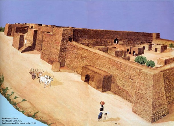
Surkotada is a small place in Kutch district of India's western state of Gujarat. Wikimapia gives the coordinates of this place roughly as 23°37'N 70°50'E , which places it roughly about 120 Km Northeast of Bhuj City and about 22 Km Northeast of town of Rapar. An ancient mound with an height of about 16 to 26 feet stands at this site, surrounded by undulating rising ground and small sandstone hillocks covered with red soil giving this entire region a reddish brown colour. Surrounding landscape is almost barren with patches of scarce vegetation consisting of cactus, small Bhabul and Pilu trees and thorny shrubs.


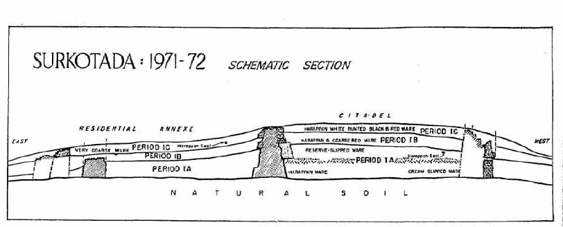
In 1964, Mr. Jagat Pati Joshi of the Archaeological Survey of India, discovered this mound as a possible site of human settlement of pre-historic times. In the ancient days, a small river flowed past the north-eastern side of the site and emptied into the Little Rann. This might have been an important reason for siting the town here. Now this river is only a small seasonal stream. Archaeological survey of India undertook excavation work on this mound first in 1970-71, when it was found that the settlement consisted of a citadel and a lower city adjacent to it. The excavations were continued next year (1971-72), when it was confirmed that the settlement was inhabited in a sequence of three fold cultures labelled as 1A,1B and 1C, roughly belonging to periods: Period 1A (2100 BC - 1950 BC) ,Period1B (1950 BC - 1800 BC) and top layer Period 1C (1800 BC to 1700 BC). From this it was clear that the earliest inhabitants of this settlement were people from Indus civilization, popularly known as Harappans from the Bronze age.


At the close of period IB, a devastating fire had spread all over the settlement indicated by an uneven and thick layer of ash spread throughout the site. However the settlement was continuously in use even there after. In the next sub period or period 1C new people had occupied the settlement. The site also revealed a large number of animal bones from the different sub periods from three categories, firstly Domesticated animals, secondly animals living in vicinity of settlement like hog, rat etc and thirdly animals that were hunted for food like deer.

Surkotada settlement was not unique in any sense. Many such settlements have been found in the Indian sub-continet over years. What made this settlement unique and special was finding the bones of a domesticated animal, found no where else, in any of the excavations carried out so far in the Indus -Ghaggar basins. This animal was Equus caballus Lin or in plain English a Horse. In fact, the archeologist from the team, Mr. A.K.Sharma was very clear, when he reported existence of incisor and molar teeth, various phalanges and other bones of Equus caballus Lin (Horse) along with bones of other horse like animals Equus asinus and Equs hemionus khur (wild asses) in the top layer 1C. He also reported finding of many Equus bones in other layers, which may not have been necessarily that of a horse.

The discovery was so sensational that most of the archeologists, indologists and historians simply refused to believe this. The discovery just made all the grand theories of Aryan invasion of India, propounded by early European historians of Indian sub continent stand on their head. Ever since John Marshall discovered the Indus civilization in 1920's, many European historians firmly believed the Aryan invasion theory. Their argument was as follows:


None of the sites excavated in Indus-Ghaggar river basins so far had come up with any evidence of a domesticated horse or Equus caballus Lin. On the other hand, in the Vedic civilization that overtook the sub continent, sometime between 1700-1500 BCE after demise of Indus civilization, horse is the most revered animal. It was argued that the Aryan invaders must have invaded Indus civilization settlements on the back of of horses around 1500 BCE in a Genghis khan style and used its speed to crushing advantage in order to subdue the native, ox-driven populations. This line of reasoning was regarded as so evident and foolproof that it was taken to be the final word on the issue.

This darling theory of the European historians was now just being proved wrong by an humble archeologist from India, who was claiming that a domesticated horse was already known and was used by Harappans from 2000 BCE onwards, a period much earlier to the supposed arrival of the Aryan warriors.

(To be concluded)

13 January 2013