Showing posts with label water. Show all posts

Friday, March 20, 2015

Water water, everywhere, on earth and in space


The Taklamakan Desert, located in northwest China is the world's second largest shifting sand desert with about 85% made up of shifting sand dunes. It is spread over an area of 337,000 km2 (130,116 sq. mi.). Because it lies in the rain shadow of the Himalayas,Taklamakan is a paradigmatic cold desert climate with almost no rain fall. There is very little underground water in the Taklamakan Desert and it is hazardous to cross even though in recent years, China has constructed a cross-desert highway.

Sven Anders Hedin, (1865 – 1952) was a Swedish geographer and explorer who made an attempt to cross the Taklamakan in spring of 1895 from north to south. On 10th April he left on his expedition with seven camels and three local escorts. He had hoped to find underground water on his way and carried only half as much water as could actually be carried. When he noticed the mistake, it was too late to return. One of his escorts died on way along with seven camels because of thirst. Hedin deserted the caravan and proceeded alone on horseback with his servant. When that escort also collapsed from thirst, Hedin left him behind as well, but at the last desperate moment managed to reach a water source right in the middle of the desert and survived.


The point I am trying to make is that there is water everywhere on earth, even in places, where probability should have been nil. I narrated Sven Hedin experience just to highlight this fact. Earth is a watery place. About 71 percent of the Earth's surface is water-covered, and the oceans hold about 96.5 percent of all Earth's water. Water also exists in the air as water vapor. At any given time, about 12,900 cubic km of water exists in the form of water vapour. Water on surface is in rivers and lakes, in icecaps and glaciers, in the ground as soil moisture and in aquifers, and even in our bodies. About 23,400,000 cubic Km water is underground.


In the recent Hollywood blockbuster “Intersteller,” an imaginary planet from another solar system called “Miller's Planet” is shown to have no land surfaces at all, with water covering its entire surface. Is it only a fragment of imagination? Or there are real planets that are totally water covered? This film depicted planets from other solar systems, but what about our own solar system? Does any other planet other than moon has presence of water on its surface?

Mars with its polar ice caps is perhaps easiest to understand. Both, northern and southern polar caps on Mars primarily contain water ice. Every winter, a surface veneer of frozen carbon-DI-oxide gas or dry ice is formed on its top. Every summer this layer vapourises, exposing the water ice in place.

Let's now come to Earth's moon. India's spacecraft Chandrayaan-1, which was launched by the ISRO in October 2008, did manage to discover water ice on surface of moon when on board impact probe was made to crash land on moon's surface. The scientists now feel that the Moon contains water in various forms. There is water that is locked up in minerals. Water is also scattered throughout the broken-up surface, and, potentially, in blocks or sheets of ice at depth.


The largest planet of our solar system is the gaseous giant Jupiter. It has as many as 67 moons, though the 4 moons discovered in 1610 by Galileo, are the most massive. Largest of these is known as Ganymede. It is the ninth largest object in the Solar System and is actually larger than Mercury. It is the largest moon in our solar system and the only moon with its own magnetic field.


NASA’s Hubble Space Telescope has found strong evidence of a massive saltwater ocean under the icy crust of Ganymede that could potentially support life. This was done by observing a natural phenomenon called aurorae, which is visible even on earth. These are natural light displays seen in polar region, most clearly seen at night against a dark sky. The magnetic field of a planet causes aurorae, which are ribbons of glowing, hot electrified gas, in regions circling the north and south poles.

Since Ganymede has its own magnetic field, observing aurorae caused by this field is not surprising. However what scientists have been able to observe is that the aurorae on Ganymede change, “rocking” back and forth. This phenomenon can be attributed to Ganymede's closeness to Jupiter, because of which, it has got embedded in Jupiter’s magnetic field. When Jupiter’s magnetic field fluctuates or changes, the aurorae on Ganymede also change, “rocking” back and forth.


Scientists say that because of the presence of s saltwater ocean on Ganymede, Jupiter’s magnetic field creates a secondary magnetic field in the ocean that counters Jupiter’s field. This “magnetic friction” suppresses the rocking of the aurorae by a large extent. It is estimated that this ocean is 100 kilometres thick — 10 times deeper than Earth’s oceans — and is buried under a 150-kilometre crust of mostly ice.

With this confirmation, Ganymede joins the ranks of two other moons that are believed to host underground reservoirs of liquid water. Evidence of similar oceans has been detected on Europa, another of Jupiter’s moons, and Enceledus, that orbits Saturn.


The biggest surprise of all is perhaps the discovery made by Nasa's Mercury Messenger spacecraft, which has been orbiting just tens of kilometres from the planet's surface. It is impossible but true that a planet where temperatures soar above 400 C could host water-ice. There are some impact craters at the north pole of Mercury that are always shadowed from the Sun, in this scorching world which turn into cold traps. Scientists feel that Comets smashing into Mercury's surface probably brought both the ice and the dark, carbon-rich (organic) material that is present in these polar cold traps.

Suddenly it seems that there is water everywhere; even on other planets and  on our solar system's moons.

18th March 2015


Friday, March 7, 2014

Alarm bells ring in Singapore


Many US cities have popular nick names. New York is known as Big Apple and Chicago is called as Windy City. Similarly, Seattle in northwest is often known as rain city. In fact, I heard in private conversations, that going outside in Seattle without an umbrella is tantamount to committing suicide? I can not give you any first hand impressions because I have never been to Seattle. But a little research on net tells me that Seattle has a relatively high amount of days per year with precipitation (158), compared to such places as New York (119), Boston (127), and Nashville (119). But these other cities get an average of about 16% more rain per year than Seattle. Which means that it rains a lot less in Seattle, but is spread out over many more days. This is why almost no native Seattle-ite carries an umbrella generally. When it does rain, it tends to be a very light drizzle that isn’t bothersome. The point I am trying to make is even if some people are calling Seattle as a rain city, it's a misnomer and no one would probably miss the rain there because it does not affect the life of residents.

There are other cities in South east Asia where it rains much more, almost on three or four days, every week round the year. Yet people are not bored with so much rain, they actually want it, as their living and well being depends upon it. Take the case of Singapore. An unusual dearth of rainfall in the month of February 2014, has raised alarm bells there. Last month has turned out to be driest month on record even when it is the shortest calender month of the year. Rain fell for just seven days during last month. Singapore's environment and water agencies announced last week in a joint statement that the city measured just 0.2 millimeters of rainfall last month, the lowest reading since rainfall records began in 1869, and well below the historical average of 161 mm. The previous record low was in February 2010, when 6.3 mm of rainfall was recorded.


Why reduced rainfall in just one calender month is raising alarm bells in Singapore? There are reasons for that. It is an island state with total land area measuring just 714 Sq. Km. It is highly urbanised state with 5.3 million inhabitants But has only about 400 Sq. Km left vacant as rain catchment area. Being a small island without any major natural aquifers and lakes and a limited land area to collect rainwater, Singapore has been forced to make serious efforts for rainwater harvesting. Rainwater is collected through a comprehensive network of drains, canals, rivers and storm water collection ponds before it is channelled to Singapore's 17 reservoirs for storage. This makes Singapore one of the few countries in the world to harvest urban storm water on a large scale for its water supply.


In spite of all this careful management of catchment areas and rain harvesting, Singapore manages only to get about 200-300 million gallons per day, depending on rainfall, from natural rain. It manages to get about 165 million gallons more from reclamation and desalination plants, though at much higher cost. It still leaves a big gap as water from these resources can meet only half it's requirements. To meet the shortfall, Singapore imports about 250 million gallons of water per day from neighbouring Malaysia. This water is available at present at a low cost. However, when the validity of the international agreement ends in 2061, Singapore is likely to face a major challenge as Malaysia has been demanding a much higher price for the water.

Singapore's PUB (public Utilities Board) says: “ Water demand in Singapore is currently about 400 million gallons a day, with homes consuming 45% and the non-domestic sector taking up the rest. By 2060, total demand could almost double, with the non-domestic sector accounting for about 70%. On the supply side, we are on track to more than triple our NEWater capacity and ramp up desalination. Together, these will be able to meet up to 80% of water demand in 2060.”


This is all fine but the crucial factor in all this planning is that there is enough rainfall in the first place, which can be harvested. The alarm bells, ringing in Singapore, just because there was no rain in last February, have to be seen in this light. Singapore weather always has a dry phase of the northeast monsoon season, around February-March. This year it has been much harsher with the parched conditions already turning the lush island-nation, brown. Even neighbouring Malaysia is facing a similar dry spell. Authorities in Selangor, the country’s most populous province, have started rationing water after levels in rivers and reservoirs there reached critical lows.


PUB Officials do not see any need for rationing water as yet in spite of the dry spell but are advising companies, building managers and residents to save water, and are discouraging residents from washing their cars and watering plants. The matter is serious though, as Prime Minister Lee Hsien Loong has advised Singaporeans through his Facebook page: “Do try your best to conserve water, and use only what you really needed.”

7th March 2014


Sunday, November 13, 2011

The Strongest takes all.

During early part of last year, news items started appearing in Indian media that China has started building a huge dam somewhere in Tibet on the Yarlungzangbo ( Yarlong Tsangpo as known to Tibetans)or Brahmaputra river. This project, known as ‘Zangmu hydroelectrical project’ was supposed to have been inaugurated on March 16,2009 and the first concrete was poured on April 2, 2009. The 1.138-billion Yuan (1 Yuan = $0.15) project was awarded to a five-company consortium with China Gezhouba Group along with NIDR (China Water Northeastern investigation, design and research) involved in its construction. This dam was expected to generate 540 MW of electrical power. As per design plans, the Zangmu dam was supposed to be a gravity dam with water-blocking structures, which could mean construction of a reservoir.


The Zangmu dam was reported to be a part of a Chinese plan to have a series of five medium-sized dams along the river in the Nanshan region of Tibet at Zangmu, Jiacha or Gyatsa, Zhongda, Jiexu and Langzhen. As expected, there was a tremendous hue and cry over this supposed Chinese river plan in India and two Indian State Govenments even requested the Central Government to take up the matter with Chinese Government and see that the project is stopped immediately.
This matter having come up at the time of the visit of Chinese President Hu Jintao to India, Chinese authorities were quick in rejecting the news as a baseless rumour to quell Indian public fears and sentiments. China’s Minister for Water Resources, Wang Shucheng, said the proposal was “unnecessary, unfeasible and unscientific, and had no government backing.” The China Daily reported, Wang Shucheng even saying that “There is no need for such dramatic and unscientific projects”. Later, Chinese Foreign Ministry spokesman Liu Jianchao said (according to the China Daily) that “The Chinese government has no plans to build a dam on the Yarlung Zangbo River”. The whole controversy seemed to have originated from a proposal, promoted by a group of retired Chinese officials earlier last year, to divert the waters of, what becomes the Brahmaputra River to China. These officials had floated these ideas in their book entitled ‘ Tibet’s water will save China’ published last year and had received a burst of publicity in China.
However, from various reports that now appear on internet, it looks almost certain that in spite of the denials, the Zangmu Hydroelectric Project, is indeed in construction. and the project is expected to be completed by 2013. This project is however just a run of the river, hydro-electrical generation project, taking advantage of the steep fall the Yarlung zangbo river has in this region and without any water diversion from the river. This should not concern India at all as the Brahmaputra river would continue to bring in same amount of water to India in future also. In fact, even if the Chinese build all the five dams on the river as planned, it would be of little consequence to India provided these are run of the river projects and there is no water diversion.
If what Chinese are saying about not diverting Yarlungzangbo river water is true, it only means that at this point of time, they must have found it to be a political hot potato and must have weighed the consequences of such an action, which directly goes against Indian and Bangladeshi Interests and must have decided to hold off any such plans for future. India (and Bangladesh) therefore, have nothing to worry about Brahmaputra waters at least for the present. Other countries, which share common borders with China, may not be that lucky.


Six of World’s mightiest rivers, Yellow, Yangtze, Brahmaputra, Indus, Salween and Mekong, all rise from the Tibetan Plateau and flow in Easterly or Northerly directions . Except for Yellow and Yangtze rivers, which flow in the Chinese mainland, all of the four remaining rivers, eventually cross Chinese borders and flow into Myanmar, Thailand, Laos, India ( not in that order) and also into illegally occupied part of Kashmir in possession of Pakistan.
A Canadian documentary maker, Michael Buckley, during his several trips to Tibet, accidentally discovered that Tibet’s river systems are being strangled by large scale dam construction. He along with a group of backpackers, moving through Tibet , discovered many newly constructed dams in the region built to divert water and hydro energy to China. China’s own river system, has been so devastated by uncontrolled industrialization that it has resulted in 70 percent of the nation’s water supply being undrinkable and unable to support aquatic life. In fact,the Dri Chu, or Yak River, which becomes the Yangtze—one of China’s most famous rivers, along with the Yellow River, now fail to reach the sea.
He says that “The rivers are dead. Chinese are not trying to fix their rivers. Their solutions are ‘Let’s take the water from Tibet’”. He feels that the diversion of water from the Tibetan highlands, to parts of northern China, is in planning stages and will be done via a vast network of concrete conduits. He says further that “China’s grand pipe-dream is to divert abundant water from the Tibetan highlands to reach water-starved cities of the north and west of China, which have around 300 million people. A diversion project of this scale enters a realm beyond anything ever attempted in water engineering.”
“The electricity produced via the hydro dams in Tibet, he added, is not for Tibetans but for Chinese industry downstream.” Michael Buckley has even produced a documentary entitled ‘Meltdown in Tibet’ on the subject.
All the downstream and riparian economy countries, except perhaps Pakistan, have realized and suddenly became aware of the threat to their water systems, as China continues to build huge dams on these rivers in Tibet and Yunnan. In fact their entire river economies are suddenly in danger.


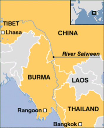
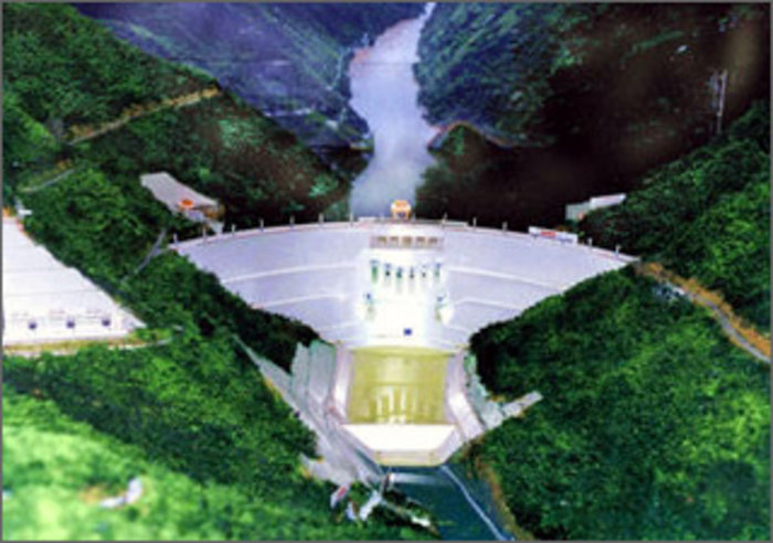
Salween river rises at 1,578 metres (5,177 ft) in the Qinghai Mountains on the Tibetan Plateau, near the headwaters of the Mekong and Yangtze rivers. It flows through China, Burma, and Thailand and empties into the Andaman Sea. The river is known as Gyalmo Ngulchu in Tibetan, meaning ‘ The Queen of Silver Water’. Canadian documentary maker Michael Buckley says that “Despite widespread protest from within China and from neighboring countries in Asia, Chinese engineers are forging ahead with plans for a cascade of 13 large dams on the Salween. Several dams are already under construction,one the height of a 60-story building.”


River Indus or Sindhu as we call it, rises in the Tibetan plateau in the vicinity of Lake Mansarovar in Tibet Autonomous Region of China. The river runs a course through the Ladakh district of Jammu and Kashmir and then enters Northern Areas (Gilgit-Baltistan) in possesion of Pakistan. Flowing in a southerly direction along the entire length of the country of Pakistan, it merges into the Arabian Sea near port city of Karachi in Sindh.
Alice Albinia, a British journalist and writer who recently visited Indus up to its roots, says in her book ‘ Empires of the Indus ‘ that the greater part of water in the River Indus came from its upper reaches, from Tibet, Ladakh and Baltistan, rather than from its Himalayan tributaries in the Punjab. She recently visited the Indus from its end point Indus Delta to its catchment area and the point of start called Senge Khabad by Tibetans, which means the lion’s mouth. It is the only place, where water did not flow from the glaciers, but the ground, and flow continued round the year.


On her way to Senge Khabab, she saw a huge dam with massive concrete curve looms up from the riverbed. The structure itself was complete, but the hydroelectric elements on the riverbed were still being installed. There are pools of water this side of the dam, but no flow. The Indus has been stopped. China had not officially informed the government of Pakistan, as there is no treaty between China and Pakistan over shared waters.
Recent Satellite Photo shows huge amount of Indus water grabbed by China, which otherwise would have flown to Pakistan
Moreover when this book was released in Pakistan, the water experts there, first refused to accept the building of a large dam in Tibet by China. Later they have simply rejected the idea of Indus water getting depleted by such a dam. This Senge Khabab dam is situated at 32 degrees and 31 minutes North latitude, and 80 degrees and 10 minutes East longitude. It is built on a tributary of Indus River, which flows from East to West joining the main (Indus) river at 32 degrees and 31 minutes North latitude, and 79 degrees and 42 minutes East longitude near the Ngari township and can be easily seen on Google Earth. The Hydroelectric power station named as Sengye Tsangpo Hydropower Station has an installed capacity of 6,400 Kilowatts and is now operational.


Now we come to perhaps the biggest and greatest grab of an international river water done by Chinese. The Dza Chu, or Mekong River, begins its life again in the mountains of Tibet and becomes a roaring torrent as it swirls through deep gorges, dropping an astonishing 4,500 meters [14,800 feet] in elevation through Tibet and China, over a distance of 1,800 km [1,118 miles],before turning tamer to enter Laos.the river is a life line for further downstream nations such as Myanmar, Cambodia, Laos, Thailand, and Vietnam.


More than 60m people from these countries depend on the Mekong River for their livelihoods. This life line of these people is under tremendous threat as parts of the river are at their lowest levels in 50 years. Further downstream, drought, salt deposits and reduced soil nutrients are threatening food production in the rice bowls of Cambodia and Vietnam. The leaders of Thailand, Cambodia, Laos and Vietnam all attended the Mekong River summit in the Thai resort of Hua Hin recently.


All the downstream countries feel that the principal reason for low water levels in the river is the on going construction of 8 dams by Chinese on the Mekong . Chinese do not accept this and say that this year’ drought and the extreme dry season are the main reasons for the low water levels. Further, Chinese want to build even more number of dams on the Mekong and feel that building of dams is the only efficient way of regulating water flow and drought relief.
When one takes an overview of all the construction activity undertaken by China in Tibet and Yunnan province, China’s grand plan of diverting abundant water from the Tibetan highlands to reach water-starved cities of the north and west of China, which have around 300 million people, becomes very clear. The scale and the grandeur of this plan is so huge that even our imagination falls short. I feel inclined to agree that the Chinese might just do it as they are not much concerned about the human tragedy and suffering that would accompany the movement of such a huge mass of people that would be required to be moved for execution of such a project .The ecological after effects of such a huge project can not be even imagined. There is a saying in English that ‘Winner takes all’. Perhaps Chinese similarly believe that the ‘Strongest takes all ‘ and would like to grab as much water as possible from the international rivers.
Unfortunately such a grand project would create great hardship and suffering for people of all the downstream countries. They need really to watch the situation and take adequate steps to safeguard their interests. For India, one geopolitical region becomes extremely important and critical now in light of this grand Chinese plan. It is the spot and surrounding areas where the Brahmaputra enters Arunachal Pradesh from Tibet. It is called the great bend. If China intends to divert water from Brahmaputra in future, they can do it only in this area. All the other areas in southern Tibet, through which Brahmaputra rushes down eastwards, are totally unsuitable for taking off water to Northern, Western or Eastern parts of China. India and China have signed an international treaty about exchange of hydrological data three times every year. Any Chinese plans to divert Brahmaputra waters would naturally reflect in this data.
This could also be one of the reasons for which, China lays it’s claims for Arunachal Pradesh. India must watch the bend.
10 April 201