Showing posts with label Himalayas. Show all posts

Sunday, April 28, 2024

Invaders of the land of seven Rivers - Chapter 1


1. The land of Saptasindhavah (सप्तसिन्धवः)


Since the dawn of civilization, the mighty Himalayas have always protected the people living in Indian sub-continent, not only from natural phenomena like sandstorms originating on central Asia plains or blistering arctic cold winds or great floodwaters sweeping the north Indian plains,  that could have created existential problems for the early settlers. The unscalable peaks and ranges of world’s tallest mountain also prevented the barbaric wild Asian steppe hordes, attacking and destroying the inhabitations, including cities and towns of subcontinent, the way they did in China and east Europe.

Yet, in spite of this guardian angel, protecting our borders, wild hordes of invaders and intruders, cruel and murderous tribesmen, monarchs, brave warriors with monarchy aspirations and people who themselves were pushed out from their country, found routes that circumambulated  the vast mountain ranges and enter the sub-continent over last two millennia. These intruders and their barbaric armies, created a profound impact on the culture of the sub-continent that had evolved over last five or more millennia, starting from Sindhu-Sarswati Civilization, the Vedic era, Buddhist ideas and finally the Sanatan Dharma. Some of the early intruders adopted to native religions, but some imposed their own religious doctrines, creating a great divisive force that continues to torment the sub-continent, even today.  

It so happens that the most profound impact of the intruders took place in a geographical area of the subcontinent, where Sindhu-Sarswati civilization once flourished five or more millennia ago. This land could be rightly called as the heart or core of the sub-continent culture. This region, in the northwest corner of the sub-continent, is none other than the land of seven rivers or Saptasindhavah (सप्तसिन्धवः) of the Vedas.  

In the oldest Veda or Rigveda, the sage Angirasa, while offering oblation to Sun God ‘Savita” describes him as,
अ॒ष्टौ व्य॑ख्यत्क॒कुभः॑ पृथि॒व्यास्त्री धन्व॒ योज॑ना स॒प्त सिन्धू॑न् । हि॒र॒ण्या॒क्षः स॑वि॒ता दे॒व आगा॒द्दध॒द्रत्ना॑ दा॒शुषे॒ वार्या॑णि ॥ (1.35.8)
“He has lighted up the eight points of the horizon, the three regions of living beings, the seven rivers; may the golden-eyes Savitā come hither, bestowing upon the offerer of the oblation desirable riches.”

The next question that naturally arises is the names of rivers that constitute this land of seven rivers.  Luckily Rigveda helps us even here. The Nadistuti sukta (नदिस्तुति सूक्त), or "the hymn in praise of rivers", gives us names of these seven rivers for the reconstruction of the geography of this area.

The first and foremost river that this Sukta (10.75.1) mentions is obviously Sindhu or The Indus, the mightiest of them all. Other rivers that are mentioned (10.75.5) in east to west direction are Sarasvati, Shutudri (Sutlej), Parushni (Iravati, Ravi), Asikni (Chenab) and finally Vitasta (Jhelum). This defines the land of seven rivers as the region that begins with Sarswati in the east, but does not end with Indus in the west.  

The next verse (10.75.6) describes the tributaries like Kubha (Kabul River), Gomati (Gomal) and  Krumu (Kurram),that merge with Sindhu in the plains.  Using this information, we can create a map of the landmass, which Rigveda describes as ‘Saptasindhav’. We must also include here the plains, west of Indus River that stretch to the mountains and also the Basin of no longer visible  Sarswati River, now found only through archaeological and satellite data. However, we shall not indulge in that endeavor as it is unrelated to our subject matter.   Figure 1.1 shows the exact locations of these rivers except River Sarswati.

 By Dbachmann, CC BY-SA 3.0, https://commons.wikimedia.org/w/index.php?curid=883227


From the image, we can imagine the vastness of this landmass. Considering present political situation, it consists of entire country of Pakistan, some parts of Afghanistan and Indian Punjab. Before we proceed further, it is important to clarify an issue, in which a few people, particularly from our western neighbor tend to believe.  After discovery of Indus culture (Now called Sindhu-Sarswati civilization) by Mr. Banerji of Archaeological survey of India, European historians started endorsing an imaginary idea of Aryan invasion, on land of seven Rivers and destruction of so called native or ‘Anarya’ culture that existed there before. However, the archeological and other data from extensive excavations in Saraswati basin by Archaeological Survey of India, Deccan College Pune and others have conclusively proved that no evidence have been found anywhere that can support this theory and the Aryan invasion theory stands rejected.

We can say with confidence therefore that history of land of seven Rivers, during Sindhu- Sarswati civilization does not include any major military campaigns by outsiders and it got extinguished due to several other reasons, which are out of our scope. Next we come to Vedic period (1500-to-1200 BCE) and Mahabharata (840 BCE) period, where major wars were only fought by indigenous armies and no external army or power was involved.  This however does not mean there were no wars fought between ‘Saptasindhav’ kingdoms and ‘Tochari’ people, their northwest neighbours. These probably were just local conflicts as no large scale invasion record has been found anywhere.

From Mahabharata period we shall move ahead by two three centuries or so and we come to a period around middle of sixth century BCE. Buddhism was spreading fast in north and northwest India.  With the monks travelling everywhere in the region, information about India, its riches, was spreading very fast.  It was no wonder therefore that foreign powers, kings and monarchs, ever eager to expand their kingdoms and monarchies, must have gathered this information and plans were afoot to invade this golden land.

With this background, we can label the arrival of the first invader army to land of seven Rivers as beginning of an evil period that intermittently continued until 1760 CE, only to be replaced by an even more cunning adversary, the British and later bifurcation of this most fertile and beautiful land itself.

(To be continued)


27th April 2024


Tuesday, April 22, 2014

A tourist destination par excellence!


As the schools close for summer holidays, there is a great rush everywhere in the world to travel. People in the western world, rush to beaches, whereas Indians prefer cool destinations like Shimla, Manali in Himalayas and obviously Kashmir. A new trend has appeared in tourism industry since last 2 or 3 decades. Most of the people now prefer packaged tours, in which a travel company takes care of all the requirements and needs of individual travellers. Since they are travelling in a group, the costs also come down.

What are the most preferred destinations of Indians for summer travel? Kashmir would be the first choice for everyone, who has not been there. Its pristine beauty is so overpowering that the memories are almost unforgettable. After Kashmir come many other destinations in the states of Himachal Pradesh, Sikkim. Kingdom of Bhutan and North eastern states including Arunachal Pradesh. Many people also want to travel to Ladakh, the northern most region of India, where ordinary citizens are freely allowed to travel.


However if you ask a real connoisseur today about his choice of a tourist destination, he is likely to brush off most of the places I have listed above because there is a new tourist destination that has just opened up its doors to tourists. Its virgin, awe inspiring beauty, unspoiled by any kind of human interference is simply breath taking. There is absolutely nothing similar to this wonderland anywhere else in the world. By now, many of you must have guessed the name correctly. It is the southernmost continent of Antarctica. But a tour to Antarctica does not come cheap; it will lighten your pocket by Rs. 1,80,000 (US$ 3000) per person for a tour by a plane that directly lands on the icy continent and lasts just about 5 hours. Or if you prefer the conventional way, you can travel by ship to the continent. This is likely to set you off by Rs. 4,00,000 (US$6000)to Rs.8,00,000 (US$ 12000) for every person.

Why do people want to travel to Antarctica? The popular tourist guide 'Lonely Planet' gives this reason: Many people come just for the wildlife: the penguins, seals, whales and seabirds are beautiful and unafraid of humans. Others want the thrill of crossing an often-heaving ocean to a remote land where people are mere visitors. Some just want to be able to attain their seventh and last continent.

Environment of Antarctica is protected by Treaty of the Antarctic and the Madrid Protocol, which bans almost all economic activities like mineral extraction on this white continent. Fortunately, Tourism is one of the few economic activities that are allowed by this Treaty. As a result, more than 35,350 people are likely to visit Antarctica this year. This figure is higher by about 1,000 from figure of last season and 8,000 more than in 2011-2012, according to the International Association of Antarctic Tour Operators.


How do these tours operate? Let us first see the shorter one day/two day tour by air. These tours start from Punta Arenas in the south of Chile, from where Antarctica is just 2 hours flying time away. The aircraft lands on hard ice and then Tourists trudging in single file line move on. The tourists can either visit the island of King George, in the South Shetlands archipelago and the neighboring Russian station of Bellingshausen with its out-of-place Orthodox church or tour Half Moon Island, a habitat of seals and penguins that is home to the Argentine base of Teniente Camara. There they can sip a hot cup of coffee, send a postcard and get their passport stamped with a picture of a krill, a kind of small shrimp that is the symbol of the baseHowever to reach starting point of the tour, Punta Arenas, one needs to take a flight from Chilean capital Santiago or take a cruise ship. Following is the tour itinerary of a tour operator aeroviasdap

Day Program :

- Transfer from hotel to Punta Arenas Airport to board the DAP plane with destination to King George Island (Antarctica)
- At your arrival, you will be welcomed by our Antarctica-expert tour guide, who will take you on a tour visiting the following venues:
- 'Villa Las Estrellas' (First settlement inhabited by civilians)
- Visit to the Drake Passage area, where we will observe a colony of different seals along
the beach.
- Lunch or a snack depending on the place and time of arrival.
-Navigation on a zodiac boat to Ardley Island to visit some penguin colonies.
-Navigation to Collins glacier.
-Return to Punta Arenas after a 5-hour tour (depending on weather conditions).


The two day itinerary goes on something like this:

- Passengers will be taken on a caterpillar truck to the Ice Camp based on Collins glacier, located about 10 km. (6 miles) from the runway. Where you will stay overnight.
-Visit to the Collins glacier and scientific bases the next day.
-Walk to the "Elefanteras" (sea elephant colony)
-It is also possible to visit other tourist attractions, depending on the weather conditions, before returning to Punta Arenas.


For tourists who have more money to spare and time, they can travel by ship. Ninety percent of the tourists from around the world who come to Antarctica leave from Ushuaia. The cruises last an average of 11 days. The cruise ships cross Drake Passage in the Southern Ocean, which has some of the world’s worst weather, setting off from either Ushuaia in southern Argentina or from Punta Arenas in Chile. On this tour your transportation, meals and accommodation are all arranged on board of the ship so that no infrastructure is required to be built ashore in Antarctica's delicate environment.


The tour mostly consists of shore landings using rigid inflatable craft powered by outboard engines, known as Zodiacs. The tourists visit penguin rookeries, scientific research stations and historic sites - and also go on cruises through fields of beautiful icebergs. Lectures are also arranged on the ship about the continent and its wildlife.

There can be no doubt that visiting Antarctica can be once in a lifetime experience. People usually plan for years to visit here. But the travel may be well worth the efforts and the money spent.

22nd April 2014


Friday, March 14, 2014

Nature's deadly bombing spells


All over the central region of peninsular India, which is also called as Deccan, there are three seasons every year. We have a moderate winter followed by scorching hot summer that usually ends around June and then a rainy season that extends up to October. Normally, it does not rain in other seasons except in the rainy season, though we do have thunderstorms that happen during transitional months such as September -October or April-May. The thunderstorms that appear in early summer days, are particularly welcomed by people because they bring down the peaking summer temperatures for few days and make the weather quite pleasant in otherwise torrid summer.

One of my pleasant childhood memories is about such summer thunderstorms that were preceded by showers of hail, which essentially are pellets of frozen rain that fall in showers from cumulonimbus clouds. Usually hail are small tiny pellets that do not cause much harm. I always remember that we would run out in the open yard with flat dishes in our hands to collect these icy pellets and bring them back home. When we could collect enough of them, we would chew them in our mouth giving us a fantastic cool feeling, which no Ice Cream or chilled drink can ever match. For years and years, I had always believed that hailstorm are freak acts of mother nature that harm no one.


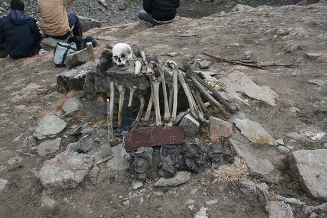
Roopkund is a high altitude glacial lake in Uttarakhand state of India that lies in the lap of Trishul massif in Himalayas. It is located at an altitude of about 5,029 meters (16,499 feet) and is surrounded by rock-strewn glaciers and snow clad mountains, making it a good trekking destination. The lake remains frozen except for few summer months. In the year 1942, a 'Nanda Devi game reserve' ranger, H K Madhwal discovered that hundreds of human skeletons along with objects like wooden artifacts, iron spearheads, leather slippers, rings etc. were lying at the clear bottom of the shallow Roopkund lake, which has a depth of about 2 meters.


Extensive investigations have been carried out by scientists from India and also from foreign lands about these skeletons. Scientific tests revealed that the skeletons belonged to several groups of people, including a group of short people (probably local porters) and a taller group who were closely related - with DNA mutations characteristic for Kokanastha Brahmins (Chitpavans) from Maharashtra. A DNA test conducted by the Centre for Cellular and Molecular Biology (CCMB), Hyderabad, indicated that three samples with unique mutation in mitochondrial DNA, matched with those of the Chitpavans. Radiocarbon dating of the bones at Oxford University's Radiocarbon Accelerator Unit determined the time period to be AD 850 ±30 years.


Obviously, nothing could be found out as to where the group was headed to. There is no historical evidence of any trade routes to Tibet in this area, but Roopkund is located on an important pilgrimage route of the Nanda Devi cult with Nanda Devi Raj Jat festivities taking place approximately once every twelve years. After elaborate investigations, researchers have concluded that the death was due to a fatal blow on the back of their heads and not due to any wound by weapons, avalanche or landslide. The marks on their skulls and shoulders indicated at being hit by something round, like a cricket ball. The absence of injuries to other body parts indicated that hard round objects, were possibly cricket ball sized hail stones or ice balls, that fell from above.


After I came to know about this tragedy from past history, my entire perception of hailstorms changed dramatically. I realised that hailstorms were not pleasant showers of tiny icy pellets that brought chilly pleasures on a hot summer afternoon but rather a deadly natural bomb attack that can destroy lives, property and standing crops.


After seeing the photographs of the destruction and damage that has been caused in the state of Maharashtra in India for last fortnight by hailstorms, I am convinced that my preconception about hailstorms as deadly natural bomb attacks, has been proved absolutely right without any doubt. As per reports published in one news paper; Indian Express, the loss and damage is beyond any precedence. This report says:

“The unusual spell of hailstorm and heavy rainfall that started more than a fortnight ago has claimed 28 lives in Maharashtra, officials said on Wednesday. Of the 28 districts that have been hit, Beed has seen the maximum number of casualties at five, followed by four deaths in Nagpur and three each in Solapur, Hingoli, and Nanded.

A total of 13.70 hundred thousand hectares of cultivated land of the summer crop season have been destroyed of which 12.71 hundred thousand hectares are under grains and 98,473 hectares are under fruits. A total of 18,222 houses have been damaged either partially or completely, while 7,559 poultry birds and 1,621 farm animals have died, according to government figures.”


The hailstorms have been so heavy that in the aftermath, the rural landscape looked as if it had just snowed heavily there. The state estimates it will need assistance worth over Rs 50 Billion from the Federal Government to compensate the farmers, who have lost acres of standing crops and fruit orchards.


Most of us are usually aware of damage caused by floods, but this year, nature has proved that it can show its displeasure in other ways too.

14th March 2014

Wednesday, June 26, 2013

A look at Himalayan disaster relief operations through Indian Army Tweets


Indian army started a twitter service sometime in 2012., I am their follower on tweeter and important bits of information sometimes comes through. During the relief operations, which are being carried out in Himalayas for flood affected victims, army has sent stream of tweets along with pictures and videos every day, explaining the relief work that they have been doing on that day. From the tweets it is possible to imagine the vastness of this operation and the efficiency with which army is carrying it out.

It began on 17th June 2013, when first tweet appeared which said:

“ADG PI - INDIAN ARMY ADG PI - INDIAN ARMY ‏@adgpi 17 Jun

A Column each of Army deployed in Rudra Prayag, Govind Ghat & Hemkund Sahib, Uttrakhand today morning for #floodrelief operations.”

Since this tweet, army has been sending tweets continuously, explaining what they are doing. After a couple of days, it became impossible for me to keep track of Army operations as the operation was so enormous. I thought that it would be easy to follow up with Google earth and here is the result.


The first image shows four main areas where the army has been helping trapped people. These areas are Rishikesh-Uttarkashi-Harsil-Gangotri; Rudraprayag-Kedarnath; Joshimath-Badrinath and Dharchula-Tawaghat in Pithoragarh district. The total area covered is about 225 Km in along northeast and about 140 Km along north east: or about 32000 sq. Km spread from Nepal border to Tibet border. The Army has mobilised nearly 8,100 troops, as it simultaneously reached out to thousands of stranded people in four regions.


Over next few days, they tried everything they could. On 17th-18th June, the Army opened the road up to Uttarkashi after clearing 16 landslips. It has also opened the road up to Sonprayag in the Kedarnath region after the successful launch of a bridge across the Vasuki Ganga between Mundkatiya and Sonprayag. As many as 2,500 stranded people were evacuated from Sonprayag. In these 2 or 3 days The army manged to rescue around 11,000 people, mainly from Govindghat and Harsil and around 10,000 people were provided food and medical assistance.


Troops skilled in mountain rescue operations, including paratroopers, were heli dropped to reach out to the people stranded in isolated areas along the Kedarnath and Badrinath region as the Kedarnath shrine was totally cut off, especially the stretch between Gourikund and Sonprayag, Army's newly formed air wing performed very well and effectively with its HAL-built Dhruv Advanced Light Helicopters, which can carry 10-16 people on heights of 10,000 feet. In all 11 helicopters were used and on 17th June itself 50 sorties were carried out.


The army was able to deploy 10 Specialised Mountaineering Teams in the worst-hit Kedarnath area and set up relief camps at Harsil, Joshimath, Rudraprayag and Gauchar Advanced Landing Grounds.. The Army also built a helipad at Lambaghat school at Govindghat. Since bridges on Alaknanda river were damaged efforts continued to repair the bridges over Alaknanda between Govindghat and Ghagria on Hemkund Sahib road. In Darchula sector 2 babies were even delivered by army doctors.


On 21st June the army confirmed with this tweet that

14,500 people rescued by Army in Uttarakhand #Floodrelief


This gigantic and Herculean humanitarian effort still continues as in some inaccessible pockets, people still remain trapped. Along with the tweets, army has sent number of photographs and videos, which give an idea of the stupendous work done by the Army. The army deserves full complements not only from the flood affected but all citizens of India. A great job well done!

26 June 2013