Showing posts with label Tropic of cancer. Show all posts

Wednesday, May 14, 2014

Look Maa; no shadow!


One thing that can never leave us- the earthlings- any time the Sun is up in the sky- is our shadow, which is always with us. We may go anywhere on the surface of our planet, yet our shadow would be always there. As soon as the dawn breaks in, a long shadow to the west, welcomes us. It keeps getting shorter and shorter till noon. After noon, the shadow, now falling to the east, gets longer and longer till sunset, when it suddenly disappears.

The shadow however does not fall exactly to the west in the morning and east in the evenings: it also falls little towards south or north, depending the location of the person on the surface of this planet. For northerners, the shadow never goes southwards and so also for southerners from the southern hemisphere it never goes towards north. For people staying in equatorial regions of northern hemisphere, it goes to the south on some days of the year and to the north on some days of the year. Our ancestors had realised long time ago, importance of this simple phenomenon, to find out many things; the time of the day and surprisingly the period of the year. The shadow also would tell them, where they were on the planet's surface? Whether to the north or in the south?


Everyone knows that earth rotates around the sun and completes one rotation in an year. The earth also rotates around itself, creating a day and a night. The earth's axis of rotation actually is not parallel to the axis of rotation of the sun. It is slanted or tilted at an angle of 23.5 degrees to the sun's axis. This slant is the most important thing for us, because it gives us the seasons. Because of this slant, there is an apparent motion of the sun in the earth's sky, towards north for six months and towards south for six months.

For an observer on earth, standing anywhere north of 23.5 Degrees from equator, the sun always looks little south of the zenith at noon and for a person standing south of 23.5 degrees south from the equator, the sun always appears to the north of zenith, though how far it is north or south depends upon the period of the year and observer's own position. We can therefore draw two imaginary circles on surface of the earth that are parallel to the equator. One that is 23.5 degrees north, commonly known as Tropic of cancer and another one 23.5 degrees south, commonly known as tropic of capricorn.

For any observer standing on surface of earth, between these two circles, the sun appears towards north of zenith at noon on some days of the year and towards south of zenith at noon on some days of the year.

My home town Pune in Maharashtra state of India lies exactly at 18.52d N and 73.86d E. Because of this location, except for a brief period of about 2 months, the sun always appears to the south of zenith at noon. Only during these two months, the sun appears to the north of zenith at noon. It also means that only on two days in a year, the sun appears exactly overhead or at zenith at noon. One of the day happens to be today or 14th May. Other day would follow in July. (Though I have said that overhead appearance of sun is at noon; it is to keep things simple. It does not happen exactly at noon in Pune because local time at Pune is 31 minutes behind the Indian standard time fixed for 83.5 d N longitude.)

Coming back to the shadow play, it also means that a person standing up under the sun here in Pune today at 12:31 PM, IST, would find his shadow missing. Something that can never happen otherwise. Many of the readers are likely to feel that all this is primary school geography. True! Yet I am mentioning here to highlight it's importance because, when none of the time keeping instruments of today were yet to be discovered, our ancient ancestors kept track of time and day by using this simple geographical phenomenon.

The oldest known civilization in India is known as Indus or Harappan civilization. Roughly 4 to 5 thousand years before, this advanced civilization, existed in the northwestern corner of India. Dholavira is the fifth largest of eight major Harappan sites discovered in India and Pakistan from the Indus civilization. It was discovered in 1967-8 by J. P. Joshi of Archaeological Survey of India and is under excavation since 1990.


One of the most significant geographical facts about Dholavira is that it lies exactly on the tropic of cancer or 23.5 d north of the equator. This would mean that for 364 days of the year, the sun would be seen at Dholavira to the south of zenith at noon local time. Just on one day, which would fall on the summer solstice day (21st June), the sun would be seen exactly overhead at noon and there would be no shadow at all.

Marking off this day must have been extremely important for inhabitants of this metropolis, perhaps for two reasons. Firstly, because it was located in an extremely arid landscape with very little rainfall, the city had to know, when to expect the rains. If they could exactly pin point the summer solstice, they would know that they could expect the rain in next few weeks. The second reason for pinpointing the summer solstice day, was because Dholavira was a port city in the present Rann of Kutch. The water levels in the Rann, during summer were probably too low for the ships to navigate even then. But after rains, the rivers emptying into the Rann would start flooding it. The water level would rise and make it possible for the ships to navigate easily.


How Dholavira people were able to mark the all important summer solstice accurately, probably would have remained a mystery, but for a chance discovery of two circular structures by two scientists: Mr. M N Vahia from the Tata Institute of Fundamental Research (TIFR), Mumbai and Mr. Srikumar Menon from Manipal School of Architecture and Planning (Karnataka). A group of of scientists now say that this discovery is the first identification of a structure used for observational astronomy during the Harappan Civilisation or in other words, these two circular structures was a functional astronomical observatory, with help of which, Dholavira people were able identify days of solar calender such as summer and winter solstice and use that information to conduct business, farming and other activities.
According to these two scientists, the circular structures, out of this complex 13 room structure, were designed for non-residential purposes. The exact purpose of these round structures was to find precisely the days of summer and winter solstice. These two circular structures probably had a flat roof with an circular opening. Authors say that a bright spot of light would fall on the floor along with its shadow. By interpreting this image and shadow, Dholavira people could exactly find out the days of summer and winter solstice.

If a wonder struck child today calls his mother on a particular day and excitedly tells her: Look Maa; no shadow! I see no reason to belittle him or her. This was exactly how, our ancestors had also discovered the simple geographical phenomenon and a child's wonderment perhaps is the reminder that it is the curiosity of a man that has made all of mankind's progress possible.

14th May 2014


Wednesday, March 6, 2013

Amazing Dholavira, Part III


From the ruins of the structures found at Dholavira and discovery of thousands of articles of daily use, pots, jewelery, weapons and the water management system, details of which we saw earlier, it would become quite clear to anyone that the Indus-Sarswati civilization was an intellectually advanced society with advanced levels of knowledge of natural phenomenon around them. Dholavira, which was part of this civilization, was a port city, from where, regular sailings of ships to inland cities in Sarswati and Indus basins as well as to Ports in Mesopotamia took place. This is not possible without possessing calendrical information such as time of the day, time of the night, seasons, years and possibly even longer periods, and understanding the movement of the heavenly objects such as stars, Sun and Moon for navigational purposes. They also needed to have precise information about the sea tides. 


Dholavira layout

During my visit to Dholavira, I had posed this question to our guide, who was kind enough to give some information about the way, basic calendrical information was maintained by the Dholavira people. According to him, certain stair cases in the Citadel ruins, were found to have 15 and 30 steps. It was easily possible, by using markers, which probably were shifted every day, to know what day of the fortnight or month that day was. By using similar methods, it was possible to know the month. This information was quite useful, but to have precise information about sea tides and seasons, they still had to have some means by which they must have related their basic calender of steps with seasonal marks like summer and winter solstice days. How they did it, probably would have remained a mystery for ever, but for a chance discovery of two circular structures, by two scientists: Mr. M N Vahia from the Tata Institute of Fundamental Research (TIFR), Mumbai and Mr. Srikumar Menon from Manipal School of Architecture and Planning (Karnataka). 


A group of of scientists now say that this discovery is the first identification of a structure used for observational astronomy during the Harappan Civilisation or in other words, these two circular structures was a functional astronomical observatory, with help of which, Dholavira people were able identify days of solar calender such as summer and winter solstice and use that information to conduct business, farming and other activities.


(Image may be copyrighted)

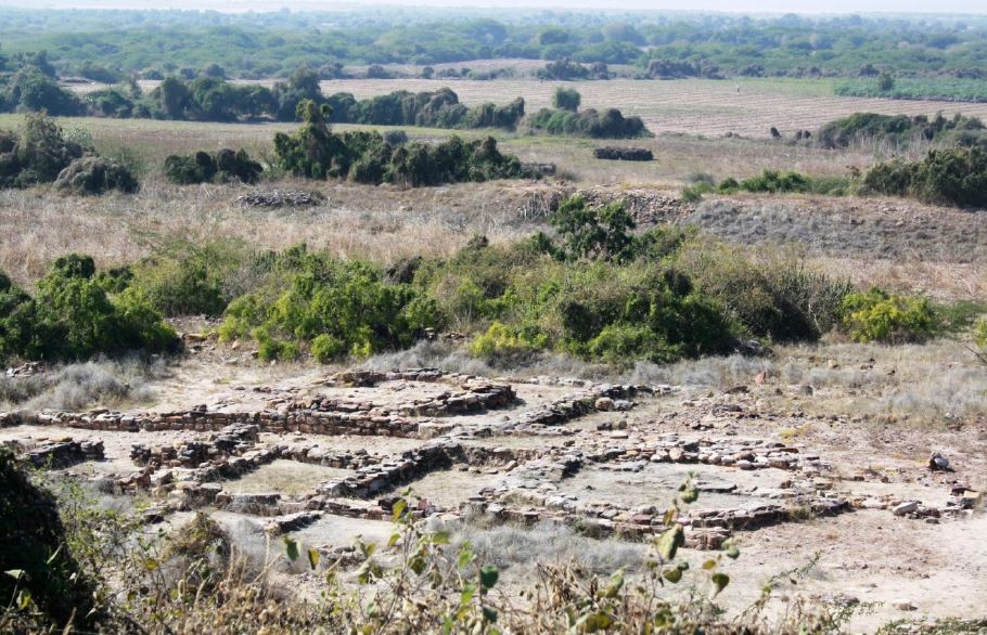
We have seen earlier that in the southeastern corner of the Dholavira city, an administrative centre of the city (named as citadel), existed within massive ramparts or walls. This citadel had two sections: castle, where residence and administrative quarters of the chief or king were located and a Bailey, where all support activities took place. M/S Vahia and Menon found ruins of a strange looking structure in this Bailey. They describe this structure in these words and I quote.

“ In the Bailey region of the city is a structure with a plan-form that is markedly different from the rest of the structures in the city and from Harappan plan-forms in general. It consists of the plinth and the foundations of what was probably a 13-room rectangular structure, of which two are circular rooms embedded within. It is located west of the Citadel and is near the edge of the terrace forming the Bailey with a drop in the west. The flat featureless horizons to the north, west and south are visible without any obstruction, while to the east the mound of the citadel obscures the horizon to a large extent. The ground slopes down to the south, where one of the artificial water reservoirs is located which would have permitted a clear view of the southern horizon.”

The authors add further:

“While structures of the Harappan civilisation do not have stone pathways leading to the entrance, these two buildings have such pathways. The whole city is inclined 6 degrees to the West of north, but the two circular structures in the Bailey have openings that are exactly to the north and west respectively. In addition, the west-facing structure has two walls that are so constructed that their shadow would just touch the entrance to the structure on winter and summer solstice days.”

According to these two scientists, the the circular structures, out of this complex 13 room structure, were designed for non-residential purposes. The exact purpose of these round structures was to find precisely the days of summer and winter solstice. Before we can understand, how these structures were used by Dholavira people, let us first note some interesting facts. The city of Dholavira is on the Tropic of Cancer (latitude 23d 26' 22''). The location of this structure is latitude 23d 53' 14.0'' N; 70d 12' 44.5''. However the earth’s axis of rotation fluctuates by about 0.5d over centuries and hence, we can assume that Dholavira lay exactly on the Tropic of Cancer. Hence the shadows of all the structures would be to the north of the structure on all days except for the local solar noon of Summer Solstice, when the Sun would come to the zenith and no shadows would be cast.
These two circular structures probably had a flat roof with an circular opening. Authors say that a bright spot of light would fall on the floor along with its shadow. By interpreting this image and shadow, Dholavira people could exactly find out the days of summer and winter solstice and using their staircase calender, would know about the month, phase of the moon and the day.


(image may be copyrighted)

The second important information that would have been required was the precise knowledge of the directions, without which sailings would have been impossible. Since there were no magnetic compasses those days ( magnetic compass was discovered only around 200-300 BCE) they had to depend for directions on stars or in particular the Polar star. Due to precession of the equinoxes,around 2000 BCE, the polar star was a weak star identified as “Thuban” today.

The authors observe:

“ Unlike all other regions, the Bailey area rises from South to North with an estimated inclination of 23.5d which corresponds to the latitude of the place. Hence standing at the southern end of the Bailey, the celestial North Pole would be seen at the top of the slope.
At the southern end of the Bailey structure are two deep square pits with no steps for entry which would be ideal to observe stars close to the azimuth even in the presence of light pollution, some amount of which would have existed even in those times.”

It would be clear that if an observer stood in one of the pits at night and looked towards north along the north-south slope of the ground in Bailey, he would have always seen “Thuban,” and would have known the true north direction on any night.

All the readers would agree that possibility of an astronomical observatory in Dholavira, as conceptualized by these two scientists, is absolutely an exciting and fascinating facet of this civilization and only shows how vibrant this civilization really was. In next part, I shall briefly touch upon the life style and religion of these people.

6 March 2013