Showing posts with label Indus-Sarswati civilization. Show all posts

Friday, August 30, 2013

India's melting pot


Inamgaon is a small village located on the right bank of Ghod river, about 85 Km from the city of Pune, located in the central Deccan plateau of the Indian peninsula. There is an ancient archaeological site located here, at about three miles from the village. It is a very extensive site, consisting of five mounds forming a rough semicircle, spread over an area of 65 acres (500 X 500 m). Archaeologists from Deccan College at Pune have been carrying out extensive excavation work at this site for a span of 14 years(1968-82).

This site is unique and extremely important. This is perhaps the only known archaeological site, that shows proof of continuous habitation for a long and critical time from India's past that bridges the pre-historic and historic periods. Historians generally call that period from the past, which begins with times of Shakyamuni Siddhart Goutam Buddha (563 to 486 BCE) as historic period, because written records in some form or other are available from that event. The period prior to this, is generally known as pre-historic period.


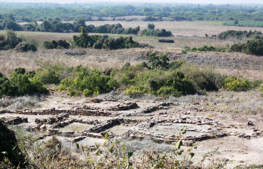
 House with circular construction excavated at Dholavira in Kutch from a period around 1600 BCE

The excavation at Inamgaon has shown that this site was inhabited from 1600 BCE to 700 BCE forming a link between the times of extinction of Indus-Sarswati civilizations in North India and times of Goutam Buddha. It is also generally believed that around 1900 to 1600 BCE, Vedic culture evolved in India, slowly taking over from the Idol worshiping, Indus-Sarswati culture. Archaeologists divide the Inamgaon habitation in three separate cultural periods: Malwa Culture (1600-1400 BCE), Early Jorwe culture (1400-1000 BCE) and late Jorwe culture (1000-700 BCE).


 Malwa culture house at Inamgaon with circular construction and sunken floor

The earliest settlers at the site were the people of the Malwa culture, who are believed to have migrated here from Malwa, which is the region from north central India (Presently part of Madhya Pradesh state) . It is believed that as water sources of habitations in Indus-Sarswati civilizations to further northeast, became scarce, people started migrating to east and south and it is likely that people of Malwa culture had moved there originally from Indus-sarswati basins.


  Jorwe culture house at Inamgaon with rectangular circular construction and sunken floor

The next settlers at Inamgaon were the people, who probably came from the Pravara-Godavari valleys (Part of Deccan plateau only) sometime after the middle of the second millennium BCE. The excavations show that there appears to be an appreciable overlap between these two phases of occupation.

In most of the archaeological sites, cultural periods form vertical layers at a site and digging deeper and deeper would normally mean going back in time. Here at Inamgaon, excavations from different cultural periods were done at the same horizontal level with the artifacts and objects that are discovered in one trench, pointing out to one specific period and culture only.

Americans think of USA as a great melting pot, where people of different races and from different regions on earth, have got together and have evolved a new American culture and society. Did something similar happen in Inamgaon? Where people from a distinct northern culture, melted with people, who were already settled in the region or who had earlier come in from Malaysia and Andaman-Nicobar islands.

Historically speaking, the societies in India have been bound completely in a rigid caste system, that allows only endogamy or marrying within your own group or caste. What did then happen at Inamgaon? Was there a caste-based system in force or was it a melting pot of people migrating from north and people who had earlier reached there after possibly travelling from Malaysian peninsula or from Andaman-Nicobar islands?

The findings of a new research project appear to confirm now, the melting pot theory. This project was undertaken by a group of scientists, Priya Moorjani, Kumarasamy Thangaraj, Nick Patterson, Mark Lipson, Po-Ru Loh, Periyasamy Govindaraj, Bonnie Berger, David Reich and Lalji Singh, Scientists from Harvard Medical School and the CSIR-Centre for Cellular and Molecular Biology in Hyderabad, India. The report is titled as 'Genetic Evidence for Recent Population Mixture in India' and has been published in the latest issue of 'American Journal of Human Genetics.' According to this report, genetic studies carried out under this project confirm:

“ Most Indian groups descend from a mixture of two genetically divergent populations: Ancestral North Indians (ANI) related to Central Asians, Middle Easterners, Caucasians, and Europeans; and Ancestral South Indians (ASI), not closely related to any groups outside the subcontinent.”

Researchers working on this project found that bloodlines of each and every person, whose blood was examined, could be traced back to two original ancestral groups, one hailing from Africa and the other from Eurasia. These two groups mingled, married and swapped genes. But at some mysterious point in history, compared to other people from Europe and Asia, which look positively homogeneous, the Indian population divided along linguistic, religious and tribal lines, to the point where it separated into 4,635 distinct genetic groups.


Would this mean that a melting pot like a possible one at Inamgaon, stopped melting suddenly and froze? But when did it happen? Was it before Inamgaon settlement or sometime after that? The researchers have been able to find clear and unambiguous answers for this question. They say that the genetic mixture between Ancestral North Indians (ANI) and Ancestral South Indians (ASI), started happening around 4200 years ago ( around 2200 CBE) or during mature Harappa period. From this time till about first century CE or 1900 years ago, ANI-ASI mixtures occurred continuously for next 2100 years. The report says:

"It was a time of profound change, characterised by the de-urbanisation of the Indus civilisation, increasing population density in the Gangetic system, and the likely appearance of Indo-European languages and Vedic religion."

But then something strange happened, and this genetic mixing of ANI and ASI stopped suddenly and completely and the melting pot froze. The report says that this point of time (First century CE) is surprisingly, few centuries later than the believed time, when caste system was codified in religious texts. Megasthenes in his Indica circa 300 BCE, and the contemporaneous Arthashastra both mention about caste system so also other epics like Mahabharata. This really means that endogamy was not commonly prevalent, for centuries even after the system was codified by religious texts. (However, The Manusmriti, which forbade intermarriage between castes, is however believed to have been written later, around 1st century CE.)

Genetically speaking, freezing the melting pot, can not be considered as a beneficiary event for a society. This report correctly points out this aspect:

“An important consequence of these results is that the high incidence of genetic and population-specific diseases that is characteristic of present-day India is likely to have increased only in the last few thousand years when groups in India started following strict endogamous marriage.”

Coming back to Inamgaon, we can conclude that it was a true melting pot and hundreds of places like Inamgaon must have helped in evolving the modern Indian people and culture. Let us now see whether we can co-relate the facts mentioned in this report with historically known facts.

Ever since 10000 BCE there has been a steady migration to Indian peninsula from northwest. The migrated people established themselves into Indus-Sarswati basins. This civilization continued almost up to 2000 BCE. These people perhaps never came into contact or got mixed up with other people staying in south and who possibly could have originated from Malaysian peninsula as well as Andaman-Nicobar islands. It is no wonder that this report supports this by saying that there was no genetic mixing in this period between ANI and ASI.

As water sources dried up in Indus-Sarswati basin, there were migrations to south and east. This is where places like Inamgaon come in. As archaeologists have found out, there was an appreciable overlap between these two phases of occupation by ANI and ASI populations. This must have resulted in intermixing of bloodlines right up to period of Goutam Buddha.

What is surprising is the fact, highlighted by this report, that rigid caste divisions in the society and tradition of endogamy came in practice, from 1st century CE. This is so, because firstly, even though Vedic culture bloomed in India immediately after disappearance of Indus-Sarswati cities, yet for next 2000 years it appears from the report that no caste system was followed by the majority of people. Secondly, Buddhist culture, which advocates equality of mankind, was supreme and popular, when this practice of endogamy was strictly enforced in 1st century CE. This is very interesting, as many people believe, that the Indian caste system has been in existence ever since Vedic culture bloomed in to India about 4000 years ago. Yet there was no caste system prevalent earlier and it came into being only when Buddhist culture, that teaches equality, was supreme. In short, this means that the present-day structure of the caste system, has come into being, only relatively recently in Indian history.

The human habitat at Inamgaon and similar places therefore assume great relevance from point of genetic history of Indian people. It was here that the true Indian genetic pool was created for the first time and genetic mixing continued for next 2000 years, when suddenly a great freeze in form of the caste system came into force and froze everything.

30 August 2013


Wednesday, March 20, 2013

Amazing Dholavira Part IV


In this last part of the series I want to highlight certain aspects of the life of Dholavira residents, commonly called as Harappans. Obviously this is not an exclusive list but a few of the features of the life of these people , that I have found not only interesting but sometimes intriguing. 


Dholavira's geometry

Dholavira founders, like all other Harappans from other cities and habitats, were extremely orderly and systematic. The layout of the towns or buildings, built with mathematical precision, are a testimony for this. Michel Danino is a France born scientist, now settled in India. He has carried out extensive research about geometrical ratios found in Dholavira. In his paper “ The Metrology behind Harappan Town Planning,” he says that all sub areas of Dholavira metropolis were laid out such that their lengths and breadths were in a ratio of two integer numbers such as 5:4 or 7:6. Here are some of the ratios.


Dimension
Ratio
Entire City
5 to 4
Castle (Inner dimensions)
5 to 4
Castle (Outer dimensions)
5 to 4
Bailey
1 to 1
Middle town
7to 6
Ceremonial ground
6 to 1
Castle's outer to inner lengths
4 to 3


Danino says that these ratios match exactly the ratios found in various other mature Harappan sites such as Mohenjo-Daro, Harappa, Lothal and Surkotada. Even the directions along which layouts were planned were usually along the cardinal directions. Danino points out that “ Harappan architects and builders did not believe in haphazard constructions, but followed precise canons of aesthetics based on specific proportions.” I feel that existence of some sort of architectural or builder''s standards can not be ruled out.

Dholavira Cemeteries

Dholavira residents disposed off their dead in an area that lies to the west of the citadel, in between the bailey and the sea coast. (now Rann coast) However there is no fixed pattern of the graves as Harappans had a composite society having different ethnic / tribal communities following their own practices. In the cemetery there were cist burials that included simple cists ( a small stone-built coffin-like box), a cist in a cairn ( a man made pile of stones) circle, a circle or a half-circle containing several graves. In addition Archaeological survey of India also found seven hemispherical constructions two of which were subjected to excavations. These were huge mud brick structures, having a circular plan and hemispherical elevation. While one was designed in the form of a spoked wheel, the other was without spokes. Both the structures were made over rock-cut chambers of large dimensions.

 Spoked wheel  graves at Dholavira

(Image courtsey ASI)
Image may be copyrighted

Surprisingly, none of the graves or cists had any skeletons indicating that these graves were symbolic. or were memorial graves. ASI found that the graves were furnished with grave goods mainly in the form of pottery. One of the hemispherical structures yielded a necklace of steatite beads strung in a copper wire with a hook at either end, a gold bangle, beads in gold foil and other beads, besides specially made pottery. It is not known, how the dead were actually disposed off, whether these were cremated or were given a sea burial. ASI's R.S. Bisht has made an interesting comment. He says.

“ The hemispherical structures remind one of early Buddhist stupas. The kind of design that is of spoked wheel and unspoked wheel also remind one of the Sara-rata-chakra-citi and sapradhi-rata-chakra-citi mentioned in the Ĺšatapatha Brahmana and Sulba-sutras (Later Vedic texts).”


Dholavira's cultural activities

A city needed open spaces for community gathering on festive or special occasions, royal ceremonies, sports and entertainment and commercial activities during trading season. Dholavira being a port city, arrival of a ship would be an important event in the life of the city, when merchandise brought by the ship would be on sale. Dholavira planners had planned for this need. 


 Stadium Viewed from north gate

A huge open area measuring measured 283 m E-W and 45 to 47m N.S (ratio 6:1) was excavated by ASI. This open area, lying between citadel and middle town, was closed from all sides and entry to it was provided through two major gates, one each on east and west. It was also furnished with tiered, stepped or sloping stands on all four sides for spectators to sit and watch the events going on in the open ground. ASI names it as great stadium. Archaeologist R S Bisht says, "We found a multipurpose open field which must have been used for everything, from sports like wrestling and bullock cart races, to plays. Of course, plays in those days were not the same as today. They were more like a joyous procession with a variety of performances, including skits and dances happening at the same time.” He adds; "The stands had gates with stones that look worn out, as if bullock cart after bullock cart had passed over it. The stadium was a very popular part of the Dholavira settlement." A small portion of this field was excavated by ASI. They found row after row of peg holes, which may have been used to erect temporary stalls and dividers during performances. This excavation also revealed that the field was scattered with hundreds of jewellery beads. Mr. Bisht says, "You can imagine performers decked in beads from top to bottom, freely dancing and the beads falling everywhere.”

There was another smaller stadium called the little stadium abutting the castle in north-western corner that was separated from the great stadium by a massive stand from, but was connected to it through an opening. For what functions, this smaller stadium was used, remains unknown, but one can speculate that that this might have been the green room where performers dressed up before walking onto the main stage or it could also have been used for exclusive shows for the royalty of the time.

Yadubirsingh Rawat, director of Gujarat government's department of archaeology who was part of Bisht's original team, says, "You can call the field 'rangbhoomi' or arena or stadium. We found steps around it which were used as stands for the audience. Also, they seemed to be adding a new layer of mud to the field every year. The mud was imported from outside Dholavira." This layering gave the stage unique acoustics and sonorous quality.

Dholavira's religion
Dholavira people, like other Harappa people, were idol worshipers. They worshiped a female figurine as a symbol of Fertility. A male figurine also has been found. A Phallic symbol in form of a Lingam also has been found at Dholavira. 


A Lingam

 
A male figurine


 A figurine of a pregnant female


A female figurine


Dholavira's lifestyle

Dholavira excavations have brought to light thousands of artifacts, which give us a fair idea about the life style of these people. The main weapon of these people appears to be bow and arrow, though some copper axes and hammers also have been found. Necklaces of beads made from semi precious stones, shells, have been found. Women wore rings on their ankles as well as forearms. Cooking was done in terracotta pots and bronze utensils, surprisingly with designs still being used in Indian kitchens. This is also true for the food grinders made from stone. Weights and measures made from quartz, sling balls from stone and extremely beautiful lamp holders and gold ornaments, the list is endless. 

Copper objects


 Kitchen Utensils


Terracotta lights 


A Copper mirror

(photo curtsey ASI)
(Image may be copyrighted) 

I now come to the end of this series, I have tried to describe some of the major features of this pre-historic civilization that amazed me, but I am quite aware that I have just skimmed the surface. I would suggest to anyone interested, to read more from excellent books and reports published by ASI archaeologists.

(concluded)

20 March 2013


Wednesday, March 6, 2013

Amazing Dholavira, Part III


From the ruins of the structures found at Dholavira and discovery of thousands of articles of daily use, pots, jewelery, weapons and the water management system, details of which we saw earlier, it would become quite clear to anyone that the Indus-Sarswati civilization was an intellectually advanced society with advanced levels of knowledge of natural phenomenon around them. Dholavira, which was part of this civilization, was a port city, from where, regular sailings of ships to inland cities in Sarswati and Indus basins as well as to Ports in Mesopotamia took place. This is not possible without possessing calendrical information such as time of the day, time of the night, seasons, years and possibly even longer periods, and understanding the movement of the heavenly objects such as stars, Sun and Moon for navigational purposes. They also needed to have precise information about the sea tides. 


Dholavira layout

During my visit to Dholavira, I had posed this question to our guide, who was kind enough to give some information about the way, basic calendrical information was maintained by the Dholavira people. According to him, certain stair cases in the Citadel ruins, were found to have 15 and 30 steps. It was easily possible, by using markers, which probably were shifted every day, to know what day of the fortnight or month that day was. By using similar methods, it was possible to know the month. This information was quite useful, but to have precise information about sea tides and seasons, they still had to have some means by which they must have related their basic calender of steps with seasonal marks like summer and winter solstice days. How they did it, probably would have remained a mystery for ever, but for a chance discovery of two circular structures, by two scientists: Mr. M N Vahia from the Tata Institute of Fundamental Research (TIFR), Mumbai and Mr. Srikumar Menon from Manipal School of Architecture and Planning (Karnataka). 


A group of of scientists now say that this discovery is the first identification of a structure used for observational astronomy during the Harappan Civilisation or in other words, these two circular structures was a functional astronomical observatory, with help of which, Dholavira people were able identify days of solar calender such as summer and winter solstice and use that information to conduct business, farming and other activities.


(Image may be copyrighted)

We have seen earlier that in the southeastern corner of the Dholavira city, an administrative centre of the city (named as citadel), existed within massive ramparts or walls. This citadel had two sections: castle, where residence and administrative quarters of the chief or king were located and a Bailey, where all support activities took place. M/S Vahia and Menon found ruins of a strange looking structure in this Bailey. They describe this structure in these words and I quote.

“ In the Bailey region of the city is a structure with a plan-form that is markedly different from the rest of the structures in the city and from Harappan plan-forms in general. It consists of the plinth and the foundations of what was probably a 13-room rectangular structure, of which two are circular rooms embedded within. It is located west of the Citadel and is near the edge of the terrace forming the Bailey with a drop in the west. The flat featureless horizons to the north, west and south are visible without any obstruction, while to the east the mound of the citadel obscures the horizon to a large extent. The ground slopes down to the south, where one of the artificial water reservoirs is located which would have permitted a clear view of the southern horizon.”

The authors add further:

“While structures of the Harappan civilisation do not have stone pathways leading to the entrance, these two buildings have such pathways. The whole city is inclined 6 degrees to the West of north, but the two circular structures in the Bailey have openings that are exactly to the north and west respectively. In addition, the west-facing structure has two walls that are so constructed that their shadow would just touch the entrance to the structure on winter and summer solstice days.”

According to these two scientists, the the circular structures, out of this complex 13 room structure, were designed for non-residential purposes. The exact purpose of these round structures was to find precisely the days of summer and winter solstice. Before we can understand, how these structures were used by Dholavira people, let us first note some interesting facts. The city of Dholavira is on the Tropic of Cancer (latitude 23d 26' 22''). The location of this structure is latitude 23d 53' 14.0'' N; 70d 12' 44.5''. However the earth’s axis of rotation fluctuates by about 0.5d over centuries and hence, we can assume that Dholavira lay exactly on the Tropic of Cancer. Hence the shadows of all the structures would be to the north of the structure on all days except for the local solar noon of Summer Solstice, when the Sun would come to the zenith and no shadows would be cast.
These two circular structures probably had a flat roof with an circular opening. Authors say that a bright spot of light would fall on the floor along with its shadow. By interpreting this image and shadow, Dholavira people could exactly find out the days of summer and winter solstice and using their staircase calender, would know about the month, phase of the moon and the day.


(image may be copyrighted)

The second important information that would have been required was the precise knowledge of the directions, without which sailings would have been impossible. Since there were no magnetic compasses those days ( magnetic compass was discovered only around 200-300 BCE) they had to depend for directions on stars or in particular the Polar star. Due to precession of the equinoxes,around 2000 BCE, the polar star was a weak star identified as “Thuban” today.

The authors observe:

“ Unlike all other regions, the Bailey area rises from South to North with an estimated inclination of 23.5d which corresponds to the latitude of the place. Hence standing at the southern end of the Bailey, the celestial North Pole would be seen at the top of the slope.
At the southern end of the Bailey structure are two deep square pits with no steps for entry which would be ideal to observe stars close to the azimuth even in the presence of light pollution, some amount of which would have existed even in those times.”

It would be clear that if an observer stood in one of the pits at night and looked towards north along the north-south slope of the ground in Bailey, he would have always seen “Thuban,” and would have known the true north direction on any night.

All the readers would agree that possibility of an astronomical observatory in Dholavira, as conceptualized by these two scientists, is absolutely an exciting and fascinating facet of this civilization and only shows how vibrant this civilization really was. In next part, I shall briefly touch upon the life style and religion of these people.

6 March 2013