Showing posts with label landslide. Show all posts

Monday, October 6, 2014

A fool's errand


A senator from Pakistan's Muslim League Quaid party and chairman of a Parliamentary Panel; Mushahid Hussain Syed has come out with a report about one of the friction areas between India and Pakistan, namely the Siachin glacier. The report actually has no reality basis and is like flogging a dead horse. Before considering, why this report is a lame duck, let us find out some details about the Siachin glacier and why it is so important.

Jammu & Kashmir state of the Indian Union has been involved in a quagmire of controversy, ever since the Maharaja of the erstwhile kingdom, signed the instrument of accession in 1947. This state, even before accession to India, always had international borders with China on east and Afghanistan in the north. In 1947, when British India was divided into Pakistan and India, the state was attacked by Pakistan army invading under the disguise of Tribal warriors from Northwest. After the accession to India, Indian army had to land in Kashmir and fight back the invading Pakistani army. In this war, most of the Kashmir valley was won back by Indian forces and Pakistani forces were forced to retreat to west of Pir-Panjal mountains. Pakistan continued to hold the Baltistan region in north of Ladakh. The Prime Minister of India then refereed the matter to United Nations Security Council. After that, Pakistan has embarked upon three unnecessary wars with India over Kashmir. However, today, after 65 years, the Indian and Pakistan forces keep holding the same positions in spite of these three wars.


If we study the geography of the state of Jammu & Kashmir, it can be seen clearly that four mountain ranges divide the state into four natural parts. All these four mountain ranges run in southeast to northwest direction. The Jammu region adjoining Panjab state and the Kashmir valley are divided by Pir-Panjal range. The Nun-Kun mountains to the east of Kashmir and the Zanskar range box between them the Zanskar valley. Ladakh plateau lies between Zanskar ranges and Ladakh ranges. To the north east of Ladakh plateau and the south Karakoram ranges, the Shoyok and Nubra vallys are the last areas of habitation. To the east of Karakoram mountain lies the Tibet region. To the south end of Karakoram mountains and to the east of Leh city, the famous Karakoram pass is located. Till 1950, this was a trade route between India and Xinjiang province of China.

The LOC between India and Pakistan, crossing all these mountain ranges except Karakorams, ends at point NJ9842 roughly to northeast of Leh city but to west of Karakoram ranges. According to Shimla agreement, since entire region east of this point and right up to Tibet, consists of inaccessible mountains terrain and glaciers, both the countries had then decided to keep this as no man's land. India had assumed that this line eventually would go along the Soltoro ridge keeping Siachin glacier within India till a point on Rimo glacier, where it would meet the Chinese border. Pakistan according to its convenience decided that this line would run west to east from NJ9842 to Karakoram pass. This would have enabled Pakistan to connect the regions of Skardu and Baltistan straight to Chinese borders.

Pakistan started allowing foreign mountaineering expeditions in the Siachin region and the first Japanese team carried out an expedition there in 1978. Pakistan's idea behind this permission was a clever one. It was thought that once the international expeditions come to know that Pakistan's clearance is all that they require , internationally it would be assumed that it is a part of Pakistan. When the Indian army headquarters came to know of this development, they started sending Indian army teams to Siachin region in summer. The plan was to dissuade any foreign mountaineers from climbing in Siachin and tell them that they have entered unauthorizedly into Indian territory.


How is the Geography of this region, where Siachin glacier is located? Some authors have called it as the roof of the world. Some call it as the third pole. This glacier flowing at an avarage height of 15000 feet is spread over 72 KM. On both sides of this glacier snow clad peaks of the Karakoram up to 23000
feet tower above the glacier. The south Karakoram ridge extend on the east side whereas Soltoro ridge extends on the west side. Biting cold snow blizzards and winds blow here all the time. In winter the temperatures drop down to -40 degrees Celsius. Indian army HQ realised that if this region is to be taken under military control, it would be necessary to control the peaks on the western side or the Soltoro ridge. Otherwise Indian soldiers on the glacier would be just sitting ducks for the enemy and would be practice targets. It was a very tough task as establishing army outposts at such heights was not easy at all. In spite the advercities, Indian army was successful in establishing series of outposts on the Soltoro ridge by March/April 1984. When Pakistani soldiers arrived in this area again in the month of May, they found that Indian soldiers have occupied all the poasses leading to Siachin namely Sia La, Bilafond La, Gyong La and Chulung La. When it was realised that all the Siachin passes are now controlled by India, Pakistani soldiers retreated and established outposts on the western ridges of Soltoro. After this the war broke out.

To capture outposts on Soltoro ridge is an impossible task for any infantry unit and Pakistan army failed in their objectives totally. Since 1984 the military situation has remained more or less same till date. India controls Soltoro ridge, Siachin glacier, all passes that lead to the glacier and major parts of Shoyok and Nubra river basins. . If we study the geography of this region, the importance of Siachin can be easily appreciated. From Soltoro ridge, the Pakistan occupied Skardu region is just 40 miles away. The Siachin is shaped like a dagger into north and India's control over Siachin is perhaps the biggest headache for any expansionist plans of Pakistan. To secure this region, controlling Siachin is essential. There can be no two opinions about it.

Pakistani army has several bases and forward posts in this entire area. Pakistani military headquarters was located at Gayari in a deep valley( most of the peaks around are above 20000 feet high ), with an height of 3,775 metres (12,400 feet) above mean sea level. The Gayari base, which was about 40 miles north of Turtok, the last village under Indian control, and about 40 miles west of Siachin glacier, was one of the most important Pakistani bases in the area. It was a vital supply hub for troops and materiel passing through to more remote bases, and was not far from a military hospital. Recently, base was occupied by soldiers of the 6th Northern Light Infantry battalion, a unit "trained in mountain operations". Avalanches are very uncommon in the area of Gayari. Because of this low avalanche risk, Gayari was a bigger complex and housed many more soldiers than other bases in Pakistan controlled area west of Siachin.


On 7 April 2012, a massive ice avalanche struck this base , which originated from a point 4560 meters above sea level and at a distance of about 1300 meters from Gayari camp. The winter of 2011–2012 in Kashmir was unusually harsh, marked by numerous heavy snowfalls and sharp temperature drops. Due to this reason or something else, the entire mountainside just slid eastwards, towards the camp and Battalion headquarters was instantly buried deep in soil. The avalanche was so massive that the camp covering an area of 1 square KM was buried under 21 meters or 70 feet of snow, which made the rescue efforts almost impossible. As per official reports of Pakistani Army says that 124 soldiers, including a Colonel and a commander as well as 11 civil labourers were buried deep down.

Ever since this tragedy, there has been a demand in Pakistan to reevaluate the Siachin strategy. Pakistan's then Army commander, also had made some suggestions in this direction. It appears that the Parliament panel headed by Mushahid Hussain Syed was appointed to address this concern because the panel's report clearly mentions this fact as;

“We should learn from the Gyari tragedy, which resulted in the loss of 140 lives. The tallest post is at the height of 22,000 ft and it takes 21 days of slow climbing to reach the peak. There are specially trained troops, who can survive such harsh living conditions, with temperatures that dip to minus 50 degrees. 90% of casualties are caused by the severe weather, which includes frostbite, lung and chest diseases, loss of memory and depressive episode. The most difficult moment is when a soldier falls sick and he has to be evacuated, which is a major logistical exercise.”

This is all fine, however instead of suggesting some direction to strategic thinking on this subject for Pakistan army, the report only suggests that both countries to collaborate on environmental issues, climate change and global warming and that both sides should find a formula for pulling back their forces from positions in the icy mountain, with Siachen being converted into a peace park where mountain tourism and expeditions could be encouraged under the supervision of the United Nations.


 South end of Soltoro ridge

India is least likely to take even a note of this report, because in the first place, the entire region of Baltistan and Hunza can be watched clearly from Saltoro ridge. Any collaborative activities between Pakistan and China can be monitored from here. For India, it is a very advantageous position. Secondly there happens to be another more important strategic reason. Upto 1950, trade was carried through Karakoram pass between India and central Asia and Russia via Xinjiang. There are excellent possibilities of this trade route opening again in future. Once the Rohtang tunnel on Manali-Leh road is completed, this highway would be an all weather road to Padm and Leh in Ladakh, which would mean that a trade route through Karakoram pass would be in the realm of reality. But for this to happen, this entire region has to be secured militarily. This can be achieved only if Soltoro ridge and siachin are firmly in India's hands. The presence of army there, whatever may be the cost, is essential for the future. The report of the Parliamentary panel of Pakistan therefore is most likely to be a fool's errand.

6th October 2014


Thursday, April 19, 2012

A disaster in Baltistan


Baltistan region is a part of the erstwhile Kashmir state. During British rule of India, Baltistan region was a part of the Jammu &Kashmir state ruled by the Maharaja of Kashmir. After Indian independence in 1947, Maharaja of Kashmir remained undecided about joining India or Pakistan. Pakistan Government under disguise of tribal warriors, invaded the region. When the Pakistani army reached on the outskirts of the state capital Srinagar, Maharaja of Kashmir signed Instrument of accession with India and Indian army rushed to Kashmir to defend the state against Pakistani invaders. Indian army cleared most of the Kashmir valley, but Prime minister of India decided to refer the matter to United nations security council and a cease fire was ensured. At this time a small portion of Kashmir valley and norther regions remained in Pakistani hands.
In 1972, after creation of Bangladesh, an accord was signed between Pakistan and India, in which a line of actual control was legalized. This line however was not demarcated west of a point known as NJ9842 and which lies west of the Soltoro ridge .

Siachin glacier also flows north to south on east of both Soltoro ridge and this point NJ9842 . The entire Siachin region was left unmarked during 1972 agreement. In 1984, suspicions of Pakistani maneuvers in Siachin, India launched operation Meghdoot and took control of the entire glacier region along with Soltoro ridge on the east side of the glacier and the mountain passes. Siachin glacier is strategically extremely important and crucial for control of the entire Karakoram region. Pakistan made many attempts during eighties to dis-launch the Indians from Siachin, but were unsuccessful. Eventually they were forced to take control of the area west of Soltoro ridge, which consists of high altitude mountain ranges and deep ravines. 

 
Pakistani army has several bases and forward posts in this entire area. Pakistani military headquarters was located at Gayari in a deep valley( most of the peaks around are above 20000 feet high ), with an height of 3,775 metres (12,400 feet) above mean sea level. The Gayari base, which was about 40 miles north of Turtok, the last village under Indian control, and about 40 miles west of Siachin glacier, was one of the most important Pakistani bases in the area. It was a vital supply hub for troops and materiel passing through to more remote bases, and was not far from a military hospital. Recently, base was occupied by soldiers of the 6th Northern Light Infantry battalion, a unit "trained in mountain operations". Avalanches are very uncommon in the area of Gayari. Because of this low avalanche risk, Gayari was a bigger complex and housed many more soldiers than other bases in Pakistan controlled area west of Siachin.

Around 2:00 am, Pakistan Standard Time, on 7 April 2012, a massive ice avalanche struck this base , which originated from a point 4560 meters above sea level and at a distance of about 1300 meters from Gayari camp. The winter of 2011–2012 in Kashmir was unusually harsh, marked by numerous heavy snowfalls and sharp temperature drops. Due to this reason or something else, the entire mountainside just slid eastwards towards the camp and Battalion headquarters was instantly buried deep in soil. The avalanche was so massive that the camp covering an area of 1 square KM was buried under 21 meters or 70 feet of snow, which made the rescue efforts almost impossible. As per official reports of Pakistani Army, 124 soldiers, including a Colonel and a commander , 11 civil labourers have been buried deep down and hopes of any survivals are very remote. 
 

By 9 April 2012, rescue crews which consisted of about 300 Pakistani's and 8 experts sent bu US were working at the scene of the disaster and had managed to clear an area of snow measuring approximately 12 meters in length, 9 meters in width, and 3 meters (10 feet) in depth. Official statements suggest that no bodies have been yet found. Inclement weather and fear of new avalanches generated by use of heavy excavating machinery hampered the operation.


A controversy has now come up within experts regarding whether Gayri incident is an avalanche or a landslide. Many experts believe that the difficulties faced by rescuers have arisen because the camp is not buried under snow but loose earth, which makes it almost impossible to dig under given conditions.

Pakistan has already started sending feelers to India about possible withdrawal of soldiers of both countries from Siachin area. However, considering the strategic importance of Siachin and the past history, India is unlikely to take any action of real substance. It is up to Pakistan military to take necessary steps which could prevent such mishaps for them in the future.
Surprisingly, a Chinese military website has released photo's of Gayri disaster, indicating some involvement of China in the rescue work. A video of the disaster site can be seen here. There is nothing much that India can do except offering sympathies to Pakistan. But that is life isn’t it?
19 April 2012

Saturday, March 31, 2012

The invisible River

During my visit to Coorg district of Karnataka state, India, about two years ago, I was traveling to the headwaters of Kaveri river. I came to know from the driver of my vehicle that I could visit on my way a place called Bhagmandaleshwara, where a temple of the same name is also located. At this place, I was told that I could also see a confluence of three rivers, one of which was Kaveri. I visited this confluence of three rivers. However, after going down to the river bed level, I could only see flows of two rivers joining together, I made some inquiries with the locals, who were also present there. I came to know from them that only two rivers, named Kaveri and Kanika, can be seen. When I asked them about the reasons for calling that place as a confluence of three rivers, I was told that the third river Sujyoti can not be seen because it is an invisible river. There was nothing further to say for me and I returned back to my car.

I have never been able to understand this concept of invisible rivers at many places in India. Perhaps the most glaring example of such a confluence of three rivers with one being invisible, is seen near the north Indian city of 'Alahabad', where a confluence of three famous rivers, Ganga, Yamuna and Sarswati is seen. Here again, we can only see the giant river beds of Ganga and Yamuna. The third river called as The Sarswati river, is invisible again. This Sarswati river could be considered as a sort of an epitome or paradigm of the Vedic culture civilization of pre-historic India. The Vedic culture was supposed to have blossomed and bloomed along the banks of this river, which is claimed as the grandest of all. Yet no one knows for sure, from where this river flowed? Or what was it's course? Though there are many hypotheses. This total disappearance of a giant river, where a great civilization was supposed to have blossomed along the banks, has always puzzled me. I could understand that rivers can change their course but an act of disappearance by a river was always beyond my comprehension or even imagination. It always made me skeptical.

Rivers are normally formed when rain water flowing down the steep mountain slopes in forms of small springs and brooks, joins together to form a larger and larger water body, which we call as river. If the mountains from where the river starts its course, have peaks above snow line or are at a geographical location nearer to the poles than the equator, the mountain tops would have a snow cover round the year. During summer, part of this snow would melt and would form another source of water for rivers. I always thought, that as long as either there is rain fall or snow formation, rivers would continue to flow and can not disappear just like that.

A natural phenomenon that took place near Northern borders of India, in a region known as Hunza, ( Grabbed by Pakistan in 1947 and being held by it at present.) has managed to solve the riddle in my mind about disappearance of rivers. This region of Hunza, lies roughly to the north of Leh. Hunza region is known for its picturesque natural beauty. A river, known as 'Hunza river', flows through this emerald green valley. Hunza valley is famous as an international tourist destination. Hunza river later joins Gilgit river in the south, which also subsequently joins the Indus. In January 2010, this Hunza river just disappeared. The waters flowing down to Gilgit river through Hunza river bed started dwindling down all of a sudden and in a short while, the river just dried.


Pakistan has built a road in this region (illegally grabbed by it from India) and calls it as Karakoram Highway. This road actually travels along the bank of Hunza river. In Hunza valley itself, there are 7 bridges built on the river for this road to pass through. Previous to the disappearance of Hunza river in January, this entire region was subjected to heavy earth tremors and shocks and as a result of which huge cracks and crevices were found to have been developed on the slopes of the mountain ranges here. 4th January 2010, turned out to be particularly unfortunate day for two small towns of Attabad and Ainabad . Major landslides crashed on these villages on that day, completely erasing the existence of these two villages. 20 villagers died and hundreds more were wounded heavily. This incident turned out later to be a major catastrophe for thousands of people living in Hunza valley, because the landslide straightway crashed on the riverbed of Hunza river. Entire hillside with all the debris consisting of loose earth, rocks and stones, falling into the river bed, completely blocked the flow of water. For all downstream villages, Hunza river had just suddenly disappeared.


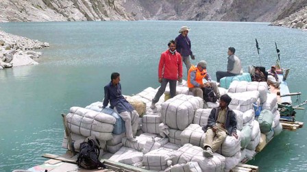
Hundreds or thousands of small rivulets, springs and brooks that flowed on the mountain sides and fed Hunza river with water, however continued to flow. Since this water had no way to flow anywhere, a huge lake started getting formed near Attabad township location. As the water level increased, about 25 KM long portion of Karakoram highway along with 7 bridges went underwater. Initially, when the landslides took place, it was the peak of winter and most of the springs and rivulets were frozen solid. However as months passed and summer approached, the Hunza lake became 17 KM long and about 353 feet deep. The towns of Fakirbad, Mayoon, Husenabad and Khan were submerged and many villages lost contact with outside world and supplies had to reach these villages only through boats plying on the lake.


Pakistan Government soon realized that disappearance of Hunza river could turn out to be a major catastrophe for the people of the region if the natural dam formed by the landslides gets breached due to increasing water pressure. In such an event,, many downstream villages were likely to be heavily flooded. It is reported that Pakistan Government found itself completely short of money and trained man power to do the job and begged to China for help. Chinese and Pakistan engineers have been trying to make the water-flow opened again in a controlled sort of way, but were not very successful till March 2010. It is estimated that about 196000 cubic meters of debris had fallen into the river bed.


By May 2010, the engineers had some success as they managed to dig out a diversionary canal from the lake about 15 meters deep. Later on, this canal has been dug to a depth of 39 meters. And as a rsult, some water is now seen flowing in the downstream river bed. As summer arrived, snow on the mountain slopes started melting and flowing towards Hunza lake. By July the new canal started carrying 17000 cusecs of water. After this, Pakistan Government officially approached China and requested to help in solving this problem.


It might be possible to open up the river in future by using modern technology and machinery and by controlled breaching of the natural dam to make Hunza river flow with its past glory. However, the entire 2010 event may also be considered as a natural demonstration by the mother nature to show how it can make rivers disappear.
I would never question anyone about truth behind disappearance of mighty Sarswati or for that matter even tiny Sujyoti river.